Galatas, Troizina
| Galatas Γαλατάς | |
|---|---|
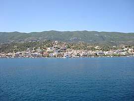 View of Galatas from Poros | |
 Galatas | |
| Coordinates: 37°29′N 23°26′E / 37.483°N 23.433°ECoordinates: 37°29′N 23°26′E / 37.483°N 23.433°E | |
| Country | Greece |
| Administrative region | Attica |
| Regional unit | Islands |
| Municipality | Troizinia-Methana |
| Municipal unit | Troizina |
| Population (2011)[1] | |
| • Rural | 2,195 |
| Community[1] | |
| • Population | 2,522 (2011) |
| Time zone | UTC+2 (EET) |
| • Summer (DST) | UTC+3 (EEST) |
Galatas (Greek: Γαλατάς), is a town located in the eastern part of the Peloponnese peninsula, Greece. It is the seat of the municipality of Troizinia-Methana, which belongs to the Islands regional unit. It is situated on the coast, opposite the island Poros, across a 400 m wide strait. The community Galatas consists of the main town Galatas and the villages Agia Sotira, Vlachaiika and Saronida.
Description
Galatas is a small mainland town with a high school, medical center, a church, banks and a new seafront plaza overlooking Poros Island. It connects to the island of Poros with water buses. The area is known for its Lemonodasos ("Lemon forest"), a vast orchard of lemon- and other citrus trees, watered by watermills and made famous by author Kosmas Politis in his 1930 novel by the same name.
Historical population
| Year | Settlement | Community |
|---|---|---|
| 1981 | 2,120 | |
| 1991 | 2,181 | |
| 2001 | 2,592 | 2,707 |
| 2011 | 2,195 | 2,522 |
Persons
- Antonios Kriezis (in Troizina 1796–1865), a soldier who fought for the Greek War of Independence and a Prime minister of Greece between December 24, 1849 – May 28, 1854
See also
| Wikimedia Commons has media related to Galatas. |
| Wikivoyage has a travel guide for Galatas. |
References
- 1 2 "Απογραφή Πληθυσμού - Κατοικιών 2011. ΜΟΝΙΜΟΣ Πληθυσμός" (in Greek). Hellenic Statistical Authority.