Gail (river)
| Gail | |
|---|---|
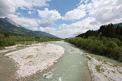 Gail River near Dellach | |
| Country | Austria |
| Physical characteristics | |
| Main source | Obertilliach, East Tyrol |
| River mouth |
Drava River near Villach 46°36′23″N 13°53′14″E / 46.60639°N 13.88722°ECoordinates: 46°36′23″N 13°53′14″E / 46.60639°N 13.88722°E |
| Length | 121.9 km (75.7 mi) [1] |
| Discharge |
|
| Basin features | |
| Progression | Drava→ Danube→ Black Sea |
| Basin size | 1,413.9 km2 (545.9 sq mi) [2] |
Gail (Slovene: Zilja, Italian: Zeglia) is the name of a river in southern Austria, the largest right tributary of the Drava.
Etymology
The name Gē'lias is of ancient Illyrian origin, denoting foaming waters. The river is documented as Gila in a 1090 deed. The Slovene name Zilja is also common as the lower Gail Valley is a traditional settlement area of the Carinthian Slovenes and a language region of the distinct Gail Valley dialect.
Course
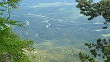
The river source is located east of the Kartitsch Saddle and the Puster Valley in the Tyrolean municipality of Obertilliach. It flows from west to east through the Southern Limestone Alps, between the Gailtal Alps in the north and the Carnic Alps in the south. The river reaches the state of Carinthia in Lesachtal and from Kötschach-Mauthen runs down the broader Gail Valley (German: Gailtal) with its steep slopes, parallel to the borders with Italy and Slovenia. Beyond its confluence with the Slizza (Gailitz) tributary in Arnoldstein, the Gail joins the Drava River beneath the western Karawanks mountain range near the village of Maria Gail, part of the city of Villach.
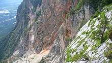
Following the 1348 Friuli earthquake, the river's course near Villach was buried by a major landslide, causing extensive flooding. The rockslide region (Schütt) along a length of 10 km (6.2 mi) is still discernible on the steep slopes of Mt. Dobratsch north of Arnoldstein.
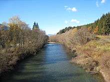
While the upper river course is largely preserved in its natural condition, a habitat for shorebirds like the common sandpiper, the white-throated dipper and the grey wagtail, large parts of the lower Gail have been gradually regulated since the 1870s. In recent times, some sections have been renaturated. Today the trout zone reaches up to Hermagor with 17 species, among them common barbel, the common nase, and the rare souffia.
Tributaries
- Gössering (left)
- Slizza (right)
Municipalities
References
External links
| Wikimedia Commons has media related to Gail. |