Trans-Gabon Railway
Coordinates: 1°37′21.92″S 13°29′21.56″E / 1.6227556°S 13.4893222°E
| Trans-Gabon Railway | |
|---|---|
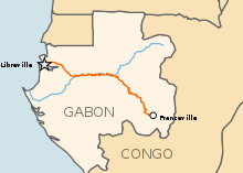 Map of the Trans-Gabon Railway line | |
| Overview | |
| Native name |
Transgabonais |
| System | Heavy rail |
| Status | Active |
| Termini |
Libreville Franceville |
| Stations | 23 |
| Operation | |
| Opened | 1987 |
| Technical | |
| Line length | 669 km (416 mi) |
| Track gauge | 1,435 mm (4 ft 8 1⁄2 in) standard gauge |
The Trans-Gabon Railway (French: Transgabonais) is the only railway in Gabon. It runs 670 km east from Owendo port station in Libreville to Franceville via numerous stations, the main ones being Ndjolé, Lopé, Booué, Lastoursville and Moanda.
History
Trans-Gabon Railway | |||||||||||||||||||||||||||||||||||||||||||||||||||||||||||||||||||||||||||||||||||||||||||||||||||||||||||||||||||||||||||||||||||||||||||||||||||||||||||||||||||||||||||||||||||||||||||||||
|---|---|---|---|---|---|---|---|---|---|---|---|---|---|---|---|---|---|---|---|---|---|---|---|---|---|---|---|---|---|---|---|---|---|---|---|---|---|---|---|---|---|---|---|---|---|---|---|---|---|---|---|---|---|---|---|---|---|---|---|---|---|---|---|---|---|---|---|---|---|---|---|---|---|---|---|---|---|---|---|---|---|---|---|---|---|---|---|---|---|---|---|---|---|---|---|---|---|---|---|---|---|---|---|---|---|---|---|---|---|---|---|---|---|---|---|---|---|---|---|---|---|---|---|---|---|---|---|---|---|---|---|---|---|---|---|---|---|---|---|---|---|---|---|---|---|---|---|---|---|---|---|---|---|---|---|---|---|---|---|---|---|---|---|---|---|---|---|---|---|---|---|---|---|---|---|---|---|---|---|---|---|---|---|---|---|---|---|---|---|---|---|
| |||||||||||||||||||||||||||||||||||||||||||||||||||||||||||||||||||||||||||||||||||||||||||||||||||||||||||||||||||||||||||||||||||||||||||||||||||||||||||||||||||||||||||||||||||||||||||||||
A railway was first planned in 1885. Investigations into the line were conducted in 1968, funding was agreed in 1973, and construction began the following year. The first section, from Owendo to Ndjolé, opened in 1978, with the remaining sections opening in stages until December 1986. Costs were well over budget and almost bankrupted the country.
The Trans-Gabon Railroad is overall adjacent the Ogooue River until Ndjolé. Most important constructions are the Juckville Tunnel, the viaduct over the Abanga swamp, and the bridge over the confluence between the Ogooue and the Ivindo Rivers.
The line to Franceville was completed in 1987.[1]
Originally intended to reach Makokou and carry iron ore, its route was changed for political reasons, namely to keep within national borders manganese ore traffic from COMILOG that went on the COMILOG Cableway via the Republic of Congo. When the railway reached the manganese mine at Moanda, the Cableway was closed.
The railway was privatised in 1999. Plans regularly surface proposing an extension to Brazzaville in the Republic of the Congo.
Construction and specifications
Because the line was built well into the era of earthmoving machinery, the need to choose a narrow gauge to save costs was no longer important. However the choice of standard gauge (1,435 mm (4 ft 8 1⁄2 in)) took advantage of off the shelf equipment. It was constructed by a consortium of Impregilo, Astaldi, Philipp Holzmann, Constructions Et Entreprises Industrielles and Entreprise De Construction Franco-Africaine.[2]
Recent history
In 2003 Hughes Network Systems (see Hughes Communications) installed a satellite based telephony system into all the railway stations of the railway.[3]
In June 2006 a new line for iron ore from Belinga to port was announced. It is unclear if it will use part of the existing line. The track will be standard gauge.[4] This line was supposed to open in 2012, but in 2014 completion is still awaited.
Two EMD JT42CWR locomotives shipped September 2011.[5][6] A further 4 locomotives and 10 passenger coaches were also ordered.[7]
Network
There are no links with the adjacent states of Equatorial Guinea, Cameroon, or the Republic of the Congo. The railway is important for transporting timber and uranium in addition to being the only important public transport route in the nation. In 1996, the railway carried 3MT of freight and 190,000 passengers.[8] The Trans-Gabon Railway, 669 km (416 mi) has 23 stations.
Trivia
- The Trans-Gabon Railway crosses the Ogooue River five times, at Franceville, at Ndjolé, and three times around Booué.
See also
References
- ↑ "Trans-Gabon Railway". Archived from the original on 2008-09-25.
- ↑ Trans-Gabon Railway Archived 2013-10-29 at the Wayback Machine.
- ↑ "Gabon Telecom Selects Hughes Network Systems' Satellite Technology to Connect Gabon Railway System", www.redorbit.com, 8 October 2003
- ↑ China given monopoly to work Gabon's untapped iron ore resources
- ↑ "LOCOS FOR SETRAG IN GABON", www.railwaysafrica.com, 20 September 2011
- ↑ "CANADIAN LOCOMOTIVE SHOPS", www.canadianrailwayobservations.com, Class 66s for Gabon, November 2011, archived from the original on 2013-01-18
- ↑ "SETRAG poursuit son développement", www.eramet-comilog.com (in French), 29 November 2011
- ↑ Janes World Railways 2002-2003
Literature
- Minko Monique. 1983. Les communications Terrestres. in Geographie et Cartographie du Gabon, Atlas Illustré led by The Ministère de l'Education Nationale de la Republique Gabonaise. Pg 86-87. Paris, France: Edicef
- Périquet; Audoin (1913), Missions d'études au Gabon . Chemin de fer du Nord et mission hydrographique (in French), Publication du Comité de l'Afrique française, Paris
- Marc Aicardi de Saint-Paul (1989), "5. Infrastructures : The Transgabon Railway", Gabon: the development of a nation, Routledge, pp. 65–67
- Bernard Peyrot (2006), "Le Transgabonais - Vecteur économique stratégique du développement du Gabon", in Jean-Louis Chaléard; Chantal Chanson-Jabeur; Chantal Béranger, Le chemin de fer en Afrique (in French), KARTHALA Editions, pp. 307–322
- "Transport Overview : Rail", The Report: Gabon 2010, Oxford Business Group, p. 127
- Katharine Murison, ed. (2002), Africa South of the Sahara 2003 (32 ed.), Europa Publications Limited / Routledge, pp. 414–415, 426
- Sven Wunder (2003), Quand le Syndrome Néerlandais rencontre la French Connection : Pétrole, Macroéconomie et Forêts au Gabon (in French), CIFOR, pp. 34-27 (section 5.2), ISBN 979-3361-35-2
External links
- "Transgabon Railway (Transgabonais) (Gabon), Railway systems and operators", articles.janes.com, Jane's
- UN Map