Gabaret Island

Gabaret Island, View from Southern Tip

Southern portion of Gabaret Island as seen across the Mississippi River from the Missouri shore
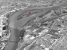
Aerial image showing Chouteau Island (green dot), Gabaret Island (blue dot), and Mosenthein Island (red dot)
Gabaret Island, also known as Cabaret Island, situated approximately eight miles (13 km) due north of the Gateway Arch in St. Louis, Missouri, and approximately one mile (1.6 km) south of the confluence of the Missouri River and Mississippi River, is one of a cluster of three islands: Chouteau Island, Gabaret Island, and Mosenthein Island.[1] Gabaret Island is 1,300 acres in area.[1] Due to land development, the island is continuous with its northern neighbor, Chouteau Island, but is separated by a slough (Gabaret Slough).[2]
Lewis and Clark camped on Gabaret Island on December 11, 1803, prior to establishing Camp Dubois near Wood River, Illinois.[2]
References
- 1 2 "Economic Development - Enterprise Zone Details". City of Madison, Illinois. Retrieved 2017-02-22.
- 1 2 Mendoza, Norma (June 24, 2002). "Public gives input on island proposal". Edwardsville Intelligencer. Retrieved February 22, 2017.
Coordinates: 38°42′56″N 90°10′48″W / 38.71556°N 90.18000°W
This article is issued from
Wikipedia.
The text is licensed under Creative Commons - Attribution - Sharealike.
Additional terms may apply for the media files.