Göta älv
| Göta älv | |
| River | |
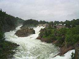 Trollhättan Falls near Göta älv in July 2004 | |
| Countries | Sweden, Norway |
|---|---|
| Source | Vänern |
| - elevation | 44 m (144 ft) |
| - coordinates | 58°22′49″N 12°21′30″E / 58.38028°N 12.35833°E |
| Mouth | Kattegat |
| - location | Gothenburg |
| - elevation | 0 m (0 ft) |
| - coordinates | 57°41′35″N 11°54′30″E / 57.69306°N 11.90833°ECoordinates: 57°41′35″N 11°54′30″E / 57.69306°N 11.90833°E |
| Length | 93 km (58 mi) 1 |
| Basin | 50,229.3 km2 (19,394 sq mi) [1] |
| Discharge | |
| - average | 575 m3/s (20,306 cu ft/s) [2] |
| Designation | |
| Official name | Nordre älvs estuarium |
| Designated | 14 November 2001 |
| Reference no. | 1125[3] |
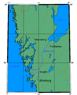 Position of the Göta älv | |
| 1: 720 km including Klarälven and Vänern [2] | |
The Göta älv (Swedish pronunciation: [ˈjøːta ˈɛlv], River of the Geats) is a river that drains lake Vänern into the Kattegat, at the city of Gothenburg, on the western coast of Sweden. It was formed at the end of the last glaciation, as an outflow channel from the Baltic Ice Lake to the Atlantic Ocean and nowadays it has the largest drainage basin in Scandinavia.
The Göta älv is located in Götaland, with the river itself being a site of early Geatish settlement. Its length is 93 km (58 mi). Usually the combination of Göta älv and Klarälven (a river ending at Vänern) is considered to be one river system. This combination is the longest river in the Nordic countries, 750 km (470 mi). The Bohus Fortress is located by the river at Kungälv. There the river splits into two, with the northern part being the Nordre älv and the southern part keeping the name Göta älv.
At Trollhättan there is a dam, canal locks and a hydropower station in the river. The locks make the river navigable, even for large cargo vessels (88 m [289 ft] long). The artificial parts are called Trollhätte Canal. The river and the canal is part of a mostly inland waterway, Göta Canal, which spans the width of Sweden to the Baltic Sea south of Stockholm.
The power station supplied electric power to the heavy steel industry concentrated around Trollhättan Falls, contributing to its industrial revolution. In the summer months the spillway of the dam is opened for a few minutes daily and tourists gather to see the water rushing down the river (picture).
There are concerns about whether the maximum discharge of 1,000 m3/s (35,000 cu ft/s) is enough in a scenario where heavy rain floods the lake Vänern, causing considerable damage. Previously this was thought not to be possible in reality, but in 2001 the lake was flooded almost 1 m (3 ft) above maximum level (and some upstream lakes like Glafsfjorden flooded 3 m [10 ft]). In this situation, Göta älv was allowed a discharge of 1,100 m3/s (39,000 cu ft/s) for months causing a big risk of landslides. Now a water tunnel between Vänersborg and Uddevalla is considered as a rescue solution.
There is a large risk of landslides along the river and historical records of 15 landslides exist. The largest occurred in the years 1150, 1648, 1950, 1957 and 1977 (Tuve landslide).
Name in other languages
In Old Norse the river was called the Gautelfr;[4] in Icelandic it is Gautelfur; and in Norwegian sometimes rendered as Gøtelv.
References
- ↑ "Län och huvudavrinningsområden i Sverige" (PDF) (in Swedish). Swedish Meteorological and Hydrological Institute. Retrieved 11 July 2010.
- 1 2 "Göta älv". Nationalencyklopedin (in Swedish). Retrieved 11 July 2010. (subscription required)
- ↑ "Nordre älvs estuarium". Ramsar Sites Information Service. Retrieved 25 April 2018.
- ↑ Richard Cleasby and Gudbrand Vigfusson, An Icelandic-English Dictionary, 2nd edn by William A. Craigie (Oxford: Oxford University Press, 1957), s.v. Gautar.
| Wikisource has the text of the 1911 Encyclopædia Britannica article Göta. |