Fyksesund
| Fyksesund | |
|---|---|
| Fyksesundet | |
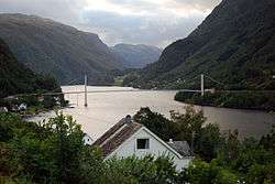 View of the fjord and bridge | |
 Fyksesund Location in Hordaland county | |
| Location | Hordaland county, Norway |
| Coordinates | 60°24′48″N 6°14′37″E / 60.4132°N 6.24367°ECoordinates: 60°24′48″N 6°14′37″E / 60.4132°N 6.24367°E |
| Primary outflows | Hardangerfjorden |
| Basin countries | Norway |
| Max. length | 11 kilometres (6.8 mi) |
Fyksesund (English: Fykse Sound)[1][2] is a fjord in the municipality of Kvam in Hordaland county, Norway. The 11-kilometre (6.8 mi) long fjord is a branch of the main Hardangerfjorden. It sits between the villages of Øystese and Ålvik, and it is surrounded by the Fyksesund Landscape Park. The fjord is spanned by the Fyksesund Bridge, which was opened by Crown Prince Olav in 1937.[3][4]
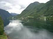
Fyksesund viewed from its Western bank
References
- ↑ "Scandinavian News: Torfin water falls". The Cook County News-Herald. September 30, 1915. p. 7. Retrieved May 23, 2017 – via Newspapers.com.

- ↑ The New Encyclopædia Britannica. 2003. Vol. 5. Chicago: Encyclopædia Britannica, p. 696.
- ↑ Rødland, Kjartan (February 13, 2009). "Klave og ku, tunnel og bru". Bergens Tidende (in Norwegian). Retrieved 2009-07-27.
- ↑ Store norske leksikon. "Fyksesund" (in Norwegian). Retrieved 2014-06-29.
This article is issued from
Wikipedia.
The text is licensed under Creative Commons - Attribution - Sharealike.
Additional terms may apply for the media files.