Fuyuan National Forest Recreation Area
Coordinates: 23°35′09.3″N 121°22′06.7″E / 23.585917°N 121.368528°E
| Fuyuan National Forest Recreation Area Chinese: 富源國家森林遊樂區 | |
|---|---|
 | |
| Geography | |
| Location | Ruisui, Hualien County, Taiwan |
| Elevation | 225-750 meters |
| Area | 191 hectares |
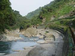
Fuyuan National Forest Recreation Area (Chinese: 富源國家森林遊樂區; pinyin: Fùyuán Guójiā Sēnlín Yóulè Qū) is a forest in Fuyuan Village, Ruisui Township, Hualien County, Taiwan.[1]
Geology
The forest is located at an elevation of 225–750 metres (738–2,461 ft) above sea level with a total area of 191 hectares (470 acres). It has an annual mean temperature of 23 °C (73 °F).[2] The Fuyuan River passes through the forest.[3] The forest consists of the Butterfly Valley and Fuyuan Waterfalls.
Facilities
The forest is equipped with BBQ area, camping ground, jungle trekking trails, etc.[4]
See also
References
- ↑ "Fu-Yuan National Forest Recreation Area" (PDF). Taiwan Forest Recreation. Retrieved 1 February 2018.
- ↑ "Fuyuan Forest Recreation Areas". Taiwan Forest Recreation. Retrieved 1 February 2018.
- ↑ "Fuyuan National Forest Recreation Area". Taiwan, the Heart of Asia. Retrieved 1 February 2018.
- ↑ "Fuyuan Forest Recreation Area". TravelKing. Retrieved 1 February 2018.
| Wikimedia Commons has media related to Fuyuan National Forest Recreation Area. |
This article is issued from
Wikipedia.
The text is licensed under Creative Commons - Attribution - Sharealike.
Additional terms may apply for the media files.