Fusillade Mountain
| Fusillade Mountain | |
|---|---|
 Fusillade Mountain with fog below summit | |
| Highest point | |
| Elevation | 8,755 ft (2,669 m) [1] |
| Prominence | 679 ft (207 m) [1] |
| Coordinates | 48°38′25″N 113°43′21″W / 48.64028°N 113.72250°WCoordinates: 48°38′25″N 113°43′21″W / 48.64028°N 113.72250°W[2] |
| Geography | |
 Fusillade Mountain | |
| Parent range | Lewis Range |
| Topo map | USGS Logan Pass, MT |
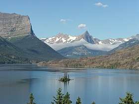
Fusillade Mountain (8,755 feet (2,669 m)) is located in the Lewis Range, Glacier National Park in the U.S. state of Montana.[3] Fusillade Mountain lies immediately north of Gunsight Lake at the western terminus of the St. Mary Valley and can be seen from the Going-to-the-Sun Road. The mountain was named by George Bird Grinnell in 1891, "as a satirical gesture at W. H. Seward and Henry L. Stimson for firing a futile volley at a group of goats on the side of this mountain".[4]
See also
References
- 1 2 "Fusillade Mountain, Montana". Peakbagger.com. Retrieved July 28, 2017.
- ↑ "Fusillade Mountain". Geographic Names Information System. United States Geological Survey. Retrieved July 28, 2017.
- ↑ Logan Pass, MT (Map). TopoQwest (United States Geological Survey Maps). Retrieved July 28, 2017.
- ↑ "Historic Place Names". National Park Service. Retrieved July 28, 2017.
This article is issued from
Wikipedia.
The text is licensed under Creative Commons - Attribution - Sharealike.
Additional terms may apply for the media files.