Farkha
| Farkha | |
|---|---|
| Other transcription(s) | |
| • Arabic | فرخة |
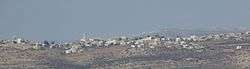 Farkha, 2016 | |
 Farkha Location of Farkha within Palestine | |
| Coordinates: 32°04′11″N 35°8′56″E / 32.06972°N 35.14889°ECoordinates: 32°04′11″N 35°8′56″E / 32.06972°N 35.14889°E | |
| Palestine grid | 164/164 |
| Governorate | Salfit |
| Government | |
| • Type | Village council |
| Elevation[1] | 587 m (1,926 ft) |
| Population (2007) | |
| • Jurisdiction | 1,336 |
| Name meaning | Furkhah, from personal name[2] |
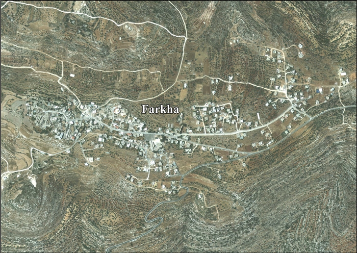
Farkha (Arabic: فرخة) is a Palestinian village located in the Salfit Governorate in the northern West Bank, 30 kilometers south of Nablus. According to the Palestinian Central Bureau of Statistics, it had a population of approximately 1,336 in 2007.[3]
Location
Farkha is located 3.2 kilometers (2.0 mi) west of Salfit. It is bordered by Salfit to the east and north, Qarawat Bani Zaid and Bani Zaid ash Sharqiya to the south, and Bruqin village to the west.[1]
History
Pottery sherds from the Middle Bronze Age, Iron Age I and IA II, Persian, Hellenistic, Roman, Byzantine and Crusader/Ayyubid have been found here.[4] An Ayyubid text in the village mosque dates it to 1210 CE.[5]
Pottery sherds from the Mamluk era has also been found here.[4] The village is seem to be the birth place of the Muslim scholar Abdullah al-Farkhawi (d. 1415).[6]
Ottoman era
In 1517, the village was included in the Ottoman empire with the rest of Palestine, and it appeared in the 1596 tax-records as Farha, located in the Nahiya of Jabal Qubal of the Liwa of Nablus. The population was 17 households, all Muslim. They paid a fixed tax rate of 33,3% on agricultural products, such as wheat, barley, summer crops, olive trees, goats and beehives, in addition to occasional revenues and a fixed tax for people of Nablus area; a total of 2,800 akçe.[7] Pottery sherds from the early Ottoman era has also been found here.[4]
In 1838, Furkha was noted as village in the Jurat Merda area, south of Nablus.[8]
In 1870, Victor Guérin on his travels noted Farkha, as a "considerable" village, located on a mountain peak.[9]
In 1882, the Palestine Exploration Fund's "Survey of Western Palestine" described Furkhah as: "An ancient village in a very strong position on a steep hill-top. The houses are of stone, and there are three sacred tombs, including Haram en Neby Shit, on the south. The fountain of Ain Yambua, in the valley, gives a supply of fine water, and there are two other springs east of the village. The place is evidently an ancient site. The hills around it are very steep and rocky."[10]
British Mandate era
In the 1922 census of Palestine conducted by the British Mandate authorities, Farkha had a population of 210 Muslims,[11] increasing in the 1931 census to 304 Muslims in 54 occupied houses.[12]
Tawfiq Canaan mention the custom of Mafazeh at the top of the ascent of Farkah; "a traveller after climbing a high mountain raises a heap of stones, or throw a stone on an existing heap, saying at the same time prayer as a mark of thanks to God that he has overcome a difficulty."[13]
In the 1945 statistics the population was 280 Muslims[14] while the total land area was 5,675 dunams, according to an official land and population survey.[15] Of this, 1,753 were allocated for plantations and irrigable land, 1,301 for cereals,[16] while 14 dunams were classified as built-up areas.[17]
Jordanian era
In the wake of the 1948 Arab–Israeli War, and after the 1949 Armistice Agreements, Farkha came under Jordanian rule.
The Jordanian census of 1961 found 564 inhabitants.[18]
Post-1967
After the Six-Day War in 1967, Farkha has been under Israeli occupation. After the 1995 accords, Israel and Israeli settlements got 80% of the water from the Western Aquifer, leading often to severe shortages of water in Farkha.[19][20]
After 1995, 48% of village land is defined as Area A land, 21.6% is Area B, while the remaining 30.4% is defined as Area C land. As of 2013, the plans for the Segregation Wall would isolate the village from much of its land behind the wall.[21]
References
- 1 2 Farkha village profile, ARIJ, p. 4
- ↑ Palmer, 1881, p. 229
- ↑ 2007 PCBS Census Archived December 10, 2010, at the Wayback Machine. Palestinian Central Bureau of Statistics. p. 112.
- 1 2 3 Finkelstein et al, 1997, p. 456
- ↑ Sharon, 2004, pp. 188 -200
- ↑ Sharon, 2004, p. 188
- ↑ Hütteroth and Abdulfattah, 1977, p. 134
- ↑ Robinson and Smith, 1841, vol 3, pp. 82-83, Appendix 2, p. 127
- ↑ Guérin, 1875, p. 159
- ↑ Conder and Kitchener, 1882, SWP II, p. 284
- ↑ Barron, 1923, Table IX, Sub-district of Nablus, p. 25
- ↑ Mills, 1932, p. 61
- ↑ Canaan, 1927, p. 76 and note 4. Cited in Sharon, 2004, p. 189
- ↑ Government of Palestine, Department of Statistics, 1945, p. 18
- ↑ Government of Palestine, Department of Statistics. Village Statistics, April, 1945. Quoted in Hadawi, 1970, p. 59
- ↑ Government of Palestine, Department of Statistics. Village Statistics, April, 1945. Quoted in Hadawi, 1970, p. 106
- ↑ Government of Palestine, Department of Statistics. Village Statistics, April, 1945. Quoted in Hadawi, 1970, p. 156
- ↑ Government of Jordan, Department of Statistics, 1964, p. 26
- ↑ Farkha village profile, ARIJ, p. 15
- ↑ Israel incapable of telling truth about water it steals from Palestinians, by Amira Hass, Jun. 22, 2016, Haaretz
- ↑ Farkha village profile, ARIJ, p. 17
Bibliography
- Barron, J. B., ed. (1923). Palestine: Report and General Abstracts of the Census of 1922. Government of Palestine.
- Canaan, T. (1927). Mohammedan Saints and Sanctuaries in Palestine. London: Luzac & Co.
- Conder, C.R.; Kitchener, H.H. (1882). The Survey of Western Palestine: Memoirs of the Topography, Orography, Hydrography, and Archaeology. 2. London: Committee of the Palestine Exploration Fund.
- Finkelstein, I.; Lederman, Zvi, eds. (1997). Highlands of many cultures. Tel Aviv: Institute of Archaeology of Tel Aviv University Publications Section. ISBN 965-440-007-3.
- Government of Jordan, Department of Statistics (1964). First Census of Population and Housing. Volume I: Final Tables; General Characteristics of the Population (PDF).
- Government of Palestine, Department of Statistics (1945). Village Statistics, April, 1945.
- Guérin, V. (1875). Description Géographique Historique et Archéologique de la Palestine (in French). 2: Samarie, pt. 2. Paris: L'Imprimerie Nationale.
- Hadawi, S. (1970). Village Statistics of 1945: A Classification of Land and Area ownership in Palestine. Palestine Liberation Organization Research Center.
- Hütteroth, Wolf-Dieter; Abdulfattah, Kamal (1977). Historical Geography of Palestine, Transjordan and Southern Syria in the Late 16th Century. Erlanger Geographische Arbeiten, Sonderband 5. Erlangen, Germany: Vorstand der Fränkischen Geographischen Gesellschaft. ISBN 3-920405-41-2.
- Mills, E., ed. (1932). Census of Palestine 1931. Population of Villages, Towns and Administrative Areas. Jerusalem: Government of Palestine.
- Palmer, E.H. (1881). The Survey of Western Palestine: Arabic and English Name Lists Collected During the Survey by Lieutenants Conder and Kitchener, R. E. Transliterated and Explained by E.H. Palmer. Committee of the Palestine Exploration Fund.
- Robinson, E.; Smith, E. (1841). Biblical Researches in Palestine, Mount Sinai and Arabia Petraea: A Journal of Travels in the year 1838. 3. Boston: Crocker & Brewster.
- Sharon, M. (2004). Corpus Inscriptionum Arabicarum Palaestinae, D-F. 3. BRILL. ISBN 90-04-13197-3.
External links
- Welcome to Farkha
- Survey of Western Palestine, Map 14: IAA, Wikimedia commons
- Farkha village (fact sheet), Applied Research Institute–Jerusalem (ARIJ)
- Farkha village profile, ARIJ
- Farkha aerial photo, ARIJ
- Development Priorities and Needs in Farkha, ARIJ
| Municipalities |
| |
|---|---|---|
| Villages | ||
| Palestinian refugee camps |
| |
| Archeological sites |
| |
| Old towns |
| |
| Israeli settlements | ||
| Outposts |
| |