Fulen (Schwyz Alps)
| Fulen | |
|---|---|
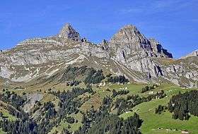 Rossstock (left) and Fulen (right) from the south | |
| Highest point | |
| Elevation | 2,491 m (8,173 ft) |
| Prominence | 311 m (1,020 ft) [1] |
| Parent peak | Chaiserstock |
| Coordinates | 46°55′7″N 8°42′53″E / 46.91861°N 8.71472°ECoordinates: 46°55′7″N 8°42′53″E / 46.91861°N 8.71472°E |
| Geography | |
 Fulen Location in Switzerland | |
| Location | Schwyz/Uri |
| Country | Switzerland |
| Parent range | Schwyz Alps |
| Topo map | Swiss Federal Office of Topography swisstopo |
The Fulen (2,491 m) is a mountain peak of the Schwyz Alps, located on the border between the Swiss cantons of Schwyz and Uri. It lies on the range between Muotathal and Unterschächen, east of Lake Lucerne.
References
- ↑ Retrieved from the Swisstopo topographic maps and Google Earth. The key col is located south of the Chaiserstock at 2,180 metres.
External links
This article is issued from
Wikipedia.
The text is licensed under Creative Commons - Attribution - Sharealike.
Additional terms may apply for the media files.