Fulde
| Fulde | |
|---|---|
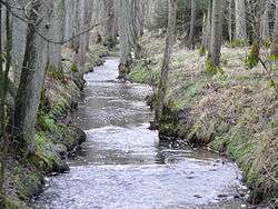 The Fulde in Eckernworth woods | |
| Location |
Heidekreis, Lower Saxony, |
| Physical characteristics | |
| Main source |
near Walsrode-Ebbingen 73 m above sea level (NN) 52°54′16″N 9°33′19″E / 52.90445°N 9.55520°ECoordinates: 52°54′16″N 9°33′19″E / 52.90445°N 9.55520°E |
| River mouth |
in Walsrode into the Böhme ca. 30 m above sea level (NN) 52°51′21″N 9°35′48″E / 52.85593°N 9.59663°E |
| Length | 11 km |
| Basin features | |
| Progression | Böhme→ Aller→ Weser→ North Sea |
| Basin size | 31.2 km² |
| Landmarks | Large towns: Walsrode |
| Population | ca. 7000 |
The Fulde belongs to the Weser river system in Germany. It is about 11 kilometres (6.8 mi) long and flows entirely within the territory of the borough of Walsrode (Heidekreis district, in the state of Lower Saxony). It rises in a valley between two parallel end moraines formed in the Saalian Ice Age. By far the largest source drains the Grundloses Moor ("bottomless moor"), 4 kilometres north of Fulde and emerges from the Kleiner See ("Little Lake") there. Another source appears 2.5 kilometres northwest of the village of Fulde, which gave the stream its name. From there the Fulde runs through, at times, picturesque scenery between steep, grass-covered, clay banks and fish ponds south of the Walsrode town forest of Eckernworth, where the Rischmannshof Heath Museum is located, crosses the centre of the town through the Fulde Park with its town hall and joins the River Böhme south of the monastery lake.
Literature
- Topographische Karte 1:25000, Blatt 3123. (Hrsg.: Landesvermessung und Geobasisinformation Niedersachsen), Hannover 2002 (1. Auflage); ISBN 3-89435-220-5