Fujikawa, Shizuoka
| Fujikawa 富士川町 | |||
|---|---|---|---|
| Former municipality | |||
| |||
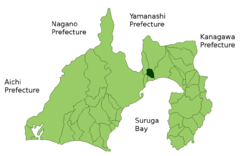 Location of Fujikawa in Shizuoka Prefecture | |||
 Fujikawa Location in Japan | |||
| Coordinates: 35°9′N 138°37′E / 35.150°N 138.617°ECoordinates: 35°9′N 138°37′E / 35.150°N 138.617°E | |||
| Country | Japan | ||
| Region | Chūbu (Tōkai) | ||
| Prefecture | Shizuoka Prefecture | ||
| District | Ihara | ||
| Merged |
November 1, 2008 (now part of Fuji) | ||
| Area | |||
| • Total | 30.92 km2 (11.94 sq mi) | ||
| Population (April 1, 2005) | |||
| • Total | 16,359 | ||
| • Density | 529/km2 (1,370/sq mi) | ||
| Time zone | UTC+9 (JST) | ||


Fujikawa (富士川町 Fujikawa-chō) was a town located in Ihara District, Shizuoka Prefecture, Japan.
As of November 2008, the town had an estimated population of 16,359 and a density of 529 persons per km². The total area was 30.92 km².
On November 1, 2008, Fujikawa was merged into the expanded city of Fuji. Ihara District was dissolved as a result of this merger.[1]
Fujikawa Village was founded on April 1, 1889. It attained town status on January 25, 1901. The town had a station (Fujikawa Station on the Tōkaidō Main Line and an interchange on the Tōmei Expressway. The view of the Tōkaidō Shinkansen crossing a bridge with Mount Fuji in the background that is still used in many tourist promotion publications for Japan was taken at Fujikawa.
References
- ↑ "Archived copy". Archived from the original on 2007-07-28. Retrieved 2008-09-08.
This article is issued from
Wikipedia.
The text is licensed under Creative Commons - Attribution - Sharealike.
Additional terms may apply for the media files.