Fuchūhommachi Station
JN20 JM35 Fuchūhommachi Station 府中本町駅 | |
|---|---|
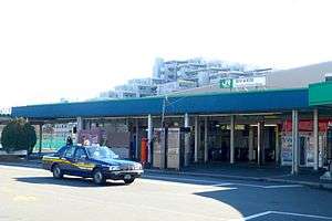 Fuchūhommachi Station forecourt in January 2014 | |
| Location |
1-29 Hommachi, Fuchū-shi, Tokyo 183-0027 Japan |
| Operated by |
|
| Line(s) |
|
| Distance | 27.9 km from Kawasaki |
| Platforms | 1 island + 2 side platforms |
| Tracks | 6 |
| Other information | |
| Website |
www |
| History | |
| Opened | 11 December 1928 |
| Traffic | |
| Passengers (FY2014) | 17,079 daily |
| Location | |
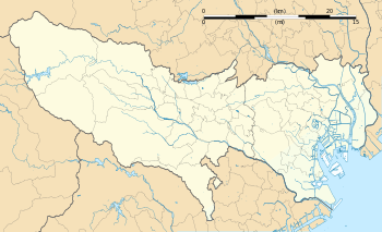 Fuchūhommachi Station Location within Tokyo | |
Fuchūhommachi Station (府中本町駅 Fuchū-Honmachi-eki) is a railway station in Fuchū, Tokyo, Japan, operated by East Japan Railway Company (JR East).[1]
Lines
Fuchūhommachi Station forms the western terminus of the orbital Musashino Line from Nishi-Funabashi and Tokyo, and is also served by the Nambu Line from Kawasaki to Tachikawa. It is located 22.8 kilometers from Tsurumi Station on the Musashino Line and 27.9 kilometers from Kawasaki Station on the Nambu Line.
Station layout
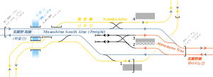
The station consists of a central island platform serving two terminating tracks for the Musashino Line, with two side platforms on either side serving the Nambu Line tracks. Through tracks are used by freight trains continuing to and from Tsurumi on the freight-only Musashino South Line.[2]
The station building is elevated and is located above the tracks and platforms. The station has a "Midori no Madoguchi" staffed ticket office.[3]
Platforms
| 1 | JN Nambu Line | for Noborito, Musashi-Kosugi, and Kawasaki |
| 2 | JM Musashino Line | Alighting passengers only |
| 3 | JM Musashino Line | for Nishi-Kokubunji, Shim-Matsudo, and Nishi-Funabashi |
| 4 | JN Nambu Line | for Bubaigawara and Tachikawa |
 View from Nambu Line platform 1 with the Musashino Line stabling sidings visible above, July 2006
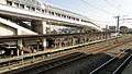 View of the southbound Nambu Line platform 1 from the Musashino Line platforms, November 2012
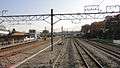 View looking south from the Musashino Line platforms, November 2012
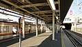 Musashino Line platforms 2 (right) and 3 (left), November 2012
 View of the northbound Nambu Line platform 4 from the Musashino Line platforms, November 2012
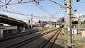 View looking north from the Musashino Line platforms, November 2012
Adjacent stations
| « | Service | » | ||
|---|---|---|---|---|
| Musashino Line JM35 | ||||
| Terminus | Musashino | Kita-Fuchū JM34 | ||
| Terminus | Local | Kita-FuchūJM34 | ||
| Nambu Line JN20 | ||||
| Inagi-Naganuma JN18 | Rapid | Bubaigawara JN21 | ||
| Minami-Tama JN19 | Local | Bubaigawara JN21 | ||
History
The station opened on 11 December 1928.[4] The Musashino Line platforms opened on 1 April 1973.[2] With the privatization of Japanese National Railways (JNR) on 1 April 1987, the station came under the control of JR East.[4]
Passenger statistics
In fiscal 2014, the station was used by an average 17,079 passengers daily (boarding passengers only).[5] The passenger figures (boarding passengers only) for previous years are as shown below.
| Fiscal year | Daily average |
|---|---|
| 2000 | 17,300[6] |
| 2005 | 16,965[7] |
| 2010 | 16,686[8] |
| 2011 | 16,565[9] |
| 2014 | 17,079[5] |
Surrounding area
- Fuchū Station (Keio Line)
- Fuchū-Keiba-Seimon-mae Station (Keiō Keibajō Line)
- Bubaigawara Station (Nambu Line)
- Tokyo Racecourse (direct access from station via special gates on race days)
- Tamagawa Kyōtei Course (boat racing)
- Fuchū City Office
- Ōkunitama Shrine
- Anyoji Temple
- Kyodo no mori museum
- Tama River
See also
References
- ↑ "JR East Railway Major Route: Metropolitan Area" (PDF). Japan: East Japan Railway Company. Archived from the original (PDF) on 23 December 2004. Retrieved 19 December 2016.
- 1 2 Kawashima, Ryozo (May 2010). 日本の鉄道 中部ライン 全線・全駅・全配線 第2巻 三鷹駅―八王子エリア [Railways of Japan - Chubu Line - Lines/Stations/Track plans - Vol 2 Mitaka Station - Hachioji Area]. Japan: Kodansha. p. 14/50. ISBN 978-4-06-270062-7.
- ↑ 各駅情報(府中本町駅) [Station Information (Fuchūhommachi Station)] (in Japanese). Japan: East Japan Railway Company. Retrieved 15 May 2016.
- 1 2 Ishino, Tetsu, ed. (1998). 停車場変遷大辞典 国鉄・JR編 [Station Transition Directory - JNR/JR]. II. Japan: JTB. p. 68. ISBN 4-533-02980-9.
- 1 2 各駅の乗車人員 (2014年度) [Station passenger figures (Fiscal 2014)] (in Japanese). Japan: East Japan Railway Company. 2015. Archived from the original on 6 May 2001. Retrieved 15 May 2016.
- ↑ 各駅の乗車人員 (2000年度) [Station passenger figures (Fiscal 2000)] (in Japanese). Japan: East Japan Railway Company. Archived from the original on 28 October 2007. Retrieved 26 November 2012.
- ↑ 各駅の乗車人員 (2005年度) [Station passenger figures (Fiscal 2005)] (in Japanese). Japan: East Japan Railway Company. Archived from the original on 16 June 2006. Retrieved 26 November 2012.
- ↑ 各駅の乗車人員 (2010年度) [Station passenger figures (Fiscal 2010)] (in Japanese). Japan: East Japan Railway Company. Archived from the original on 10 July 2011. Retrieved 26 November 2012.
- ↑ 各駅の乗車人員 (2011年度) [Station passenger figures (Fiscal 2011)] (in Japanese). Japan: East Japan Railway Company. Archived from the original on 27 July 2012. Retrieved 26 November 2012.
External links
| Wikimedia Commons has media related to Fuchūhommachi Station. |
- Fuchūhommachi Station information (JR East) (in Japanese)
Coordinates: 35°39′58″N 139°28′38″E / 35.6662055556°N 139.477202778°E