Fries Scheepvaart Museum
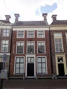
The Fries Scheepvaart Museum (English: Frisian Ship Transport Museum) is a maritime museum in the Kleinzand[1] area of Sneek, Netherlands.[2] Located in the province of Friesland, it contains a library, film viewing room, and focuses on local seafaring life.[2] It is housed in canal buildings dated to 1844 and offers collections of old sailing ships models, naval paintings, and silver pieces.[3]
History
The museum was opened on 13 April 1881 by the Provincial Friesian Society of History, Antiquity and Linguistics. The Historical Exhibition of 1877 was such a success that the Society was able to construct a building on the Rue Royale. Extension and renovation occurred in 1992-1997, to a design by architect Gunnar Daan. The multiple expansions eventually connected several canal houses, with a central entrance hall.[4] The museum celebrated its 125th anniversary in 2006. Preparations are underway for a new building of the Fries Museum in Zaailand, designed by Abe Bonnema; it was scheduled to open in September 2013.
Exhibits
Its collections include the 17th century silver IJftinus van Popta Treasure, the purported sword of Grand Pier, the Mata Hari Hall, and the Resistance Friesland. Paintings, porcelain, navigation instruments, photos, postcards, ship parts, and ship models are also displayed.[1] An ivory-carved model of a flower boat from Canton from the collection of Jan de With, a Commanders of a Dutch East India ships in the 18th century is housed at the museum.[5] In addition to the collections, there is an Elfstedentocht display and a display of the town made to resemble it in the 17th century.[4]
References
- 1 2 Gazaleh-Weevers, Sheila; Agudo, Shirley; Moser, Connie (31 December 2007). Here's Holland: Simply the Best All-in-One Guide to Travel and Life in Holland. Eburon Uitgeverij B.V. pp. 238–. ISBN 978-90-5972-141-8. Retrieved 13 December 2012.
- 1 2 Bedford, Neal; Sellars, Simon (1 March 2007). The Netherlands 3rd Edition. Lonely Planet. pp. 337–. ISBN 978-1-74104-299-3. Retrieved 13 December 2012.
- ↑ McDonald, George (31 March 2011). Frommer's Belgium, Holland and Luxembourg. John Wiley & Sons. p. 526. ISBN 978-1-118-06151-0. Retrieved 13 December 2012.
- 1 2 Dunford, Martin (17 January 2013). The Rough Guide to the Netherlands. Penguin. pp. 205–. ISBN 978-1-4093-6513-6. Retrieved 13 December 2012.
- ↑ Bruijn, Jaap R. (16 June 2011). Commanders of Dutch East India Ships in the Eighteenth Century. Boydell Press. pp. 117–. ISBN 978-1-84383-622-3. Retrieved 13 December 2012.
External links
| Wikimedia Commons has media related to Fries Scheepvaart Museum. |