Frenchman, Nevada
| Frenchman, Nevada | |
|---|---|
| Former community | |
 Frenchman | |
| Coordinates: 39°16′46″N 118°16′12″W / 39.27944°N 118.27000°WCoordinates: 39°16′46″N 118°16′12″W / 39.27944°N 118.27000°W | |
| Country | United States |
| State | Nevada |
| County | Churchill |
| Elevation | 4,157 ft (1,267 m) |
| Time zone | UTC-8 (Pacific (PST)) |
| • Summer (DST) | UTC-7 (PDT) |
| GNIS feature ID | 857995[1] |
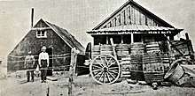
Frenchman, also known as Frenchman's Station or Bermond, was a community in Churchill County, Nevada, United States. Frenchman was located along U.S. Route 50 30 miles (48 km) east-southeast of Fallon.
The community was founded in 1904 as a stagecoach stop; it took its name from Aime "Frenchy" Bermond, a French immigrant. "Frenchy's" offered a respite for people, animals and freight traveling between Fallon, Fairview and Wonder in the early 1900's. The way station provided lodging and food, with a hotel, restaurant, saloons and stables.[2]
The U.S. Navy bought out the community in 1985 due to its proximity to the Dixie Valley bombing range, and its remaining buildings were demolished two years later.[3]
The community is mentioned in the book Blue Highways by William Least-Heat Moon, which includes a picture of Margaret and Laurie Chealander.
See also
References
- ↑ "Frenchman". Geographic Names Information System. United States Geological Survey.
- ↑ Paher, Stanley W (1970). Nevada Ghost Towns and Mining Camps. Howell North. p. 94.
- ↑ Hodges, Barbara. "Frenchman's Station aka Bermold". Online Nevada Encyclopedia. Retrieved April 29, 2017.
Municipalities and communities of Churchill County, Nevada, United States | ||
|---|---|---|
| City | 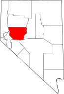 | |
| CDP | ||
| Unincorporated communities | ||
| Indian reservations | ||
| Ghost towns |
| |