French Way
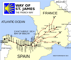
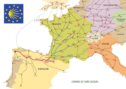
The French Way (Galician: Camiño Francés, Spanish: Camino Francés) is the most popular of the routes of the Way of St. James (Spanish: Camino de Santiago), the ancient pilgrimage route to Santiago de Compostela in Galicia, Spain. It runs from Saint-Jean-Pied-de-Port on the French side of the Pyrenees to Roncesvalles on the Spanish side and then another 780km on to Santiago de Compostela through the major cities of Pamplona, Logroño, Burgos and León. A typical walk on the Camino Francés takes at least four weeks, allowing for one or two rest days on the way. Some travel the Camino on bicycle or on horseback.
Paths from the cities of Tours, Vézelay, and Le Puy-en-Velay meet at Saint-Jean-Pied-de-Port. A fourth French route originates in Arles, in Provence, and crosses the French–Spanish frontier at a different point, between the Pyrenees towns of Somport and Canfranc. This fourth route follows the Aragonese Way and joins the French Way at Puente la Reina, south of Pamplona, in Navarre, about 700 kilometres from Santiago de Compostela.
In 2017 roughly 60% of pilgrims traveled to Santiago de Compostela via the French Way according to statistics gathered by the Pilgrim's Office in Santiago.[1]
Example itinerary
Though there is no set route, daily stages from major town to major town could be walked as follows:
| # | km from St-Jean | km to Santiago | Distance | Begins | Arrives | Passes through | Notes |
|---|---|---|---|---|---|---|---|
| 1 | 0 | 769 | 25 | Saint-Jean-Pied-de-Port, France | Roncesvalles | Crosses the border of France and Spain in the western Pyrenees. | |
| 2 | 25 | 744 | 21.5 | Roncesvalles, Spain | Zubiri | Burguete, Espinal, Viscarret, Linzoáin | |
| 3 | 46.5 | 722.5 | 22 | Zubiri | Pamplona | Larrasoaña, Trinidad de Arre | |
| 4 | 68.5 | 700.5 | 23.5 | Pamplona | Puente la Reina | Cizur Menor, Uterga, Obanos | Joined by the Aragonese Way just before Puente la Reina. |
| 5 | 92 | 677 | 22 | Puente la Reina | Estella | Cirauqui, Lorca, Villatuerta | |
| 6 | 114 | 655 | 22 | Estella | Los Arcos | Villamayor de Monjardín | |
| 7 | 136 | 633 | 28 | Los Arcos | Logroño | Torres del Río, Sansol, Viana | Leaving the province of Navarre, entering La Rioja |
| 8 | 164 | 605 | 29 | Logroño | Nájera | Navarrete, Ventosa | |
| 9 | 193 | 576 | 21 | Nájera | Santo Domingo de la Calzada | Azofra | |
| 10 | 214 | 555 | 23 | Santo Domingo de la Calzada | Belorado | Grañón, Redecilla del Camino | Leaving La Rioja, entering the Province of Burgos, Castille and León |
| 11 | 237 | 532 | 24 | Belorado | San Juan de Ortega | Tosantos, Villafranca Montes de Oca | |
| 12 | 261 | 508 | 28 | San Juan de Ortega | Burgos | Agés, Atapuerca, Olmos de Atapuerca | |
| 13 | 289 | 480 | 40 | Burgos | Castrojeriz | Villalbilla de Burgos, Tardajos, Rabé de las Calzadas, Hornillos del Camino, San Bol, Hontanas | |
| 14 | 329 | 440 | 23 | Castrojeriz | Frómista | Itero del Castillo, Puente de Fitero, Itero de la Vega, Boadilla del Camino | Leaving the province of Burgos, entering Palencia |
| 15 | 352 | 417 | 19 | Frómista | Carrión de los Condes | Población de Campos, Villacázar de Sirga | |
| 16 | 371 | 398 | 39 | Carrión de los Condes | Sahagún | Calzadilla de la Cueza, Ledigos, Terradillo del los Templarios, San Nicolás del Real Camino | |
| 17 | 410 | 359 | 19.5 | Sahagún | El Burgo Ranero | Calzada del Coto, Bercianos del Real Camino | |
| 18 | 429.5 | 339.5 | 38 | El Burgo Ranero | León | Reliegos, Mansilla de las Mulas | |
| 19 | 467.5 | 301.5 | 24 | León | Villadangos del Páramo | ||
| 20 | 491.5 | 277.5 | 28 | Villadangos del Páramo | Astorga | San Martín del Camino, Hospital de Órbigo, Santibáñez de Valdeiglesias | |
| 21 | 519.5 | 249.5 | 20 | Astorga | Rabanal del Camino | Murias de Rechivaldo, Santa Catalina de Somoza, El Ganso | |
| 22 | 539.5 | 229.5 | 32.5 | Rabanal del Camino | Ponferrada | Manjarin, El Acebo, Riego de Ambros, Molinaseca | Highest point of trail, 1515 metres above sea level, near Manjarin. |
| 23 | 572 | 197 | 23 | Ponferrada | Villafranca del Bierzo | Cacabelos | |
| 24 | 595 | 174 | 30 | Villafranca del Bierzo | O Cebreiro | Pereje, Trabadelo, La Portela de Valcarce, Vega de Valcarce, Ruitelan, La Faba | Crosses from León into Galicia. |
| 25 | 625 | 144 | 36.5 | O Cebreiro | Sarria | Hospital de la Condesa, Fonfría, Triacastela, Samos, Calvor | |
| 26 | 661.5 | 107.5 | 21 | Sarria | Portomarín | Barbadelo, Fereiros | The last point at which a pilgrim can start the journey on foot or horseback and still complete the 100km needed to claim the compostela. |
| 27 | 682.5 | 86.5 | 24.5 | Portomarín | Palas de Rei | Gonzar, Ventas de Naró, Ligonde | |
| 28 | 707 | 62 | 25.5 | Palas de Rei | Arzúa | Casanova, Leboreiro, Melide, Ribadiso da Baixo | |
| 29 | 732.5 | 36.5 | 36.5 | Arzúa | Santiago de Compostela | Santa Irene, Arca do Pino, Monte do Gozo |
Films
- The Way (2010)
References
External links
| Wikivoyage has a travel guide for French Way. |
- the French Way - Google Maps
- A photo tour of the Camino Frances (2010)
- Free Guide for Hikers on the French Way
- the French Way - Google Maps TODO MENTIRA
- http://ngm.nationalgeographic.com/2015/05/the-way/george-photography
Ways of Saint James in Europe | ||
|---|---|---|
| Spain |
|  |
| France |
| |
| Portugal | ||
| Switzerland | ||
| Poland |
| |
| Slovakia |
| |
| Austria |
| |
| ||