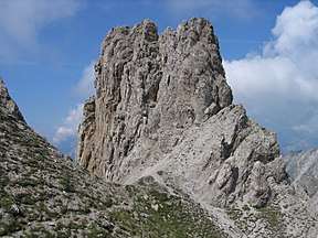
Freiungspitzen
| Freiungspitzen | |
|---|---|
 | |
| Highest point | |
| Elevation | 2,332 m (AA) (7,651 ft) |
| Prominence | 2,332-2,104 m ↓ Eppzirler Scharte |
| Isolation | 1.5 km → Reither Spitze |
| Coordinates | 47°19′00″N 11°15′35″E / 47.31667°N 11.25972°ECoordinates: 47°19′00″N 11°15′35″E / 47.31667°N 11.25972°E |
| Geography | |
| Parent range | Erlspitze Group, Karwendel |
| Geology | |
| Age of rock | Norian |
| Type of rock | main dolomite |
| Climbing | |
| First ascent | 1886/1890 by August and Fraja Lieber (tourists) |
| Normal route | Freiungen Ridgeway |

The Freiungspitzen (plural) are a group of 3 peaks in the Erlspitze Group in the Karwendel Alps on the territory of the Austrian municipality of Zirl. The highest summit, the west top, has a height of 2,332 m (AA), the middle top is 2,322 m (AA) and the east top is 2,302 m (AA).[1][2]
Ascents
The Freiungen Ridgeway (Freiungen-Höhenweg, a partially secured mountain path) between the Nördlinger Hut and the Solsteinhaus runs past the tops. The west top of the Freiungen is easy to ascend.
References
- ↑ ÖAV: Nördlinger Hütte
- ↑ According to the BEV the highest summit of the Freiungspitzen is 2,332 m high
Literature
- Walter Klier: Alpenvereinsführer Karwendel alpin, 15th edn., 2005, Bergverlag Rudolf Rother, Munich, ISBN 3-7633-1121-1
External links
This article is issued from
Wikipedia.
The text is licensed under Creative Commons - Attribution - Sharealike.
Additional terms may apply for the media files.