Franklin Township, Columbia County, Pennsylvania
| Franklin Township, Columbia County, Pennsylvania | |
|---|---|
| Township | |
 Scenery of Franklin Township from State Route 3012 | |
 Map of Columbia County, Pennsylvania highlighting Franklin Township | |
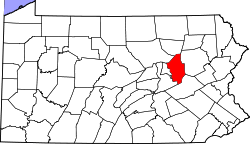 Map of Columbia County, Pennsylvania | |
| Country | United States |
| State | Pennsylvania |
| County | Columbia |
| Settled | 1783 |
| Incorporated | 1843 |
| Area[1] | |
| • Total | 13.53 sq mi (35.04 km2) |
| • Land | 13.09 sq mi (33.90 km2) |
| • Water | 0.44 sq mi (1.14 km2) |
| Population (2010) | |
| • Total | 595 |
| • Estimate (2016)[2] | 583 |
| • Density | 44.53/sq mi (17.20/km2) |
| Time zone | UTC-5 (Eastern (EST)) |
| • Summer (DST) | UTC-4 (EDT) |
| Area code(s) | 570 |
| FIPS code | 42-037-27384 |
Franklin Township is a township in Columbia County, Pennsylvania, United States. The population was 595 at the 2010 census.[3]
History
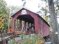
The Parr's Mill Covered Bridge No. 10, Riegel Covered Bridge No. 6, and Rohrbach Covered Bridge No. 24 was listed on the National Register of Historic Places in 1979.[4]
Geography
Franklin Township is in southwestern Columbia County, bordered by Montour County to the west and Northumberland County to the south. The Susquehanna River forms the northern border, and Roaring Creek, its tributary, crosses the township and forms part of its western boundary.
According to the United States Census Bureau, the township has a total area of 13.5 square miles (35.0 km2), of which 13.1 square miles (33.9 km2) is land and 0.42 square miles (1.1 km2), or 3.25%, is water.[3]
Demographics
| Historical population | |||
|---|---|---|---|
| Census | Pop. | %± | |
| 2010 | 595 | — | |
| Est. 2016 | 583 | [2] | −2.0% |
| U.S. Decennial Census[5] | |||
As of the census[6] of 2000, there were 597 people, 231 households, and 181 families residing in the township. The population density was 45.3 people per square mile (17.5/km²). There were 267 housing units at an average density of 20.3/sq mi (7.8/km²). The racial makeup of the township was 99.66% White, 0.34% from other races. Hispanic or Latino of any race were 0.34% of the population.
There were 231 households, out of which 33.8% had children under the age of 18 living with them, 65.8% were married couples living together, 6.5% had a female householder with no husband present, and 21.6% were non-families. 19.0% of all households were made up of individuals, and 6.9% had someone living alone who was 65 years of age or older. The average household size was 2.58 and the average family size was 2.90.
In the township the population was spread out, with 23.8% under the age of 18, 7.0% from 18 to 24, 29.6% from 25 to 44, 24.1% from 45 to 64, and 15.4% who were 65 years of age or older. The median age was 40 years. For every 100 females, there were 111.0 males. For every 100 females age 18 and over, there were 109.7 males.
The median income for a household in the township was $41,161, and the median income for a family was $42,750. Males had a median income of $29,464 versus $26,875 for females. The per capita income for the township was $17,096. About 4.5% of families and 7.2% of the population were below the poverty line, including 8.2% of those under age 18 and 3.9% of those age 65 or over.
References
- ↑ "2016 U.S. Gazetteer Files". United States Census Bureau. Retrieved Aug 13, 2017.
- 1 2 "Population and Housing Unit Estimates". Retrieved June 9, 2017.
- 1 2 "Geographic Identifiers: 2010 Census Summary File 1 (G001): Franklin township, Columbia County, Pennsylvania". U.S. Census Bureau, American Factfinder. Retrieved May 21, 2015.
- ↑ National Park Service (2010-07-09). "National Register Information System". National Register of Historic Places. National Park Service.
- ↑ "Census of Population and Housing". Census.gov. Retrieved June 4, 2016.
- ↑ "American FactFinder". United States Census Bureau. Archived from the original on 2013-09-11. Retrieved 2008-01-31.
| Wikimedia Commons has media related to Franklin Township, Columbia County, Pennsylvania. |
Municipalities and communities of Columbia County, Pennsylvania, United States | ||
|---|---|---|
| Town | | |
| Boroughs | ||
| Townships | ||
| CDPs | ||
| Unincorporated communities | ||
| Ghost Towns | ||
| Footnotes | ‡This populated place also has portions in an adjacent county or counties | |
Coordinates: 40°55′00″N 76°28′59″W / 40.91667°N 76.48306°W