Paulet–Newcombe Agreement
The Paulet–Newcombe Agreement or Paulet-Newcombe Line, was a 1923 agreement between the British and French governments regarding the position and nature of the boundary between the Mandates of Palestine and Mesopotamia, attributed to Great Britain, and the Mandate of Syria and the Lebanon, attributed to France.
Together with a preliminary 1920 agreement, these are known as the Franco-British Boundary Agreements.
December 1920 agreement
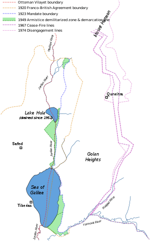
The boundary between the forthcoming British and French mandates was first defined in broad terms in the 1920 "Franco-British Convention on Certain Points Connected with the Mandates for Syria and the Lebanon, Palestine and Mesopotamia", signed in Paris by the British Ambassador to France, Charles Hardinge and the French Foreign Minister, Georges Leygues, on 23 December 1920.[1][2] That agreement placed the bulk of the Golan Heights in the French sphere.
The treaty also established a joint commission to settle the precise details of the border and mark it on the ground.[1]
March 1923 agreement
The commission submitted its final report on 3 February 1922, which included a number of amendments. The amendments included:[3]
- North East boundary moved westward (reducing the area of Palestine) to avoid splitting the lands of Emir Mahmud El-Fa’ur of Quneitra[3]
- Northern boundary moved northward (increasing the area of Palestine) to include the entire Sea of Galilee and the Yarmuk valley[3]
It was approved with some caveats by the French and British governments on 7 March 1923, several months before Britain and France assumed their Mandatory responsibilities on 29 September 1923.[4][5]
The agreements fixed the line of the Syrian-Palestinian border (now the Syrian-Israeli border) between the Mediterranean Sea and the town of Al-Hamma.[4] The 1923 agreement takes its name from French Lieutenant Colonel N. Paulet and British Lieutenant Colonel S. F. Newcombe, who were appointed to lead the Boundary Commission.[6]
See also
Notes
| Wikisource has original text related to this article: |
- 1 2 Text available in American Journal of International Law, Vol. 16, No. 3, 1922, 122–126.
- ↑ Text available in Carnegie Endowment for International Peace, American Association for International Conciliation (1921). International conciliation, Volume 166. American Branch of the Association for International Conciliation. pp. 297–303.
- 1 2 3 Biger 2004, p. 147-8.
- 1 2 Agreement between His Majesty's Government and the French Government respecting the Boundary Line between Syria and Palestine from the Mediterranean to El Hámmé. Paris, March 7, 1923., Treaty Series No. 13 (1923), Cmd. 1910. Also Louis, 1969, p. 90.
- ↑ FSU Law Archived 2006-09-16 at the Wayback Machine..
- ↑ The Seven Villages: Origins and Implication, Nicholas Blanford
Bibliography
- John J. McTague Jr., Anglo-French Negotiations over the Boundaries of Palestine, 1919-1920, Journal of Palestine Studies, Vol. 11, No. 2. (Winter, 1982), pp. 100-112.
- Franco-British Convention on Certain Points Connected with the Mandates for Syria and the Lebanon, Palestine and Mesopotamia, signed Dec. 23, 1920. Text available in American Journal of International Law, Vol. 16, No. 3, Supplement, 1922, 122-126.
- Agreement between His Majesty's Government and the French Government respecting the Boundary Line between Syria and Palestine from the Mediterranean to El Hámmé, Treaty Series No. 13 (1923), Cmd. 1910.
- Gideon Biger (1989), Geographical and other arguments in delimitation in the boundaries of British Palestine, in "International Boundaries and Boundary Conflict Resolution", IBRU Conference, ISBN 1-85560-000-5, 41-61.
- John McTague (1982), Anglo-French Negotiations over the Boundaries of Palestine, 1919-1920, Journal of Palestine Studies, Vol. 11, No. 2, 101-112.
- Yitzhak Gil-Har (1993), British commitments to the Arabs and their application to the Palestine-Trans-Jordan boundary: The issue of the Semakh triangle, Middle Eastern Studies, Vol.29, No.4, 690-701.
- Muhsin Yusuf (1991), The Zionists and the process of defining the borders of Palestine, 1915-1923, Journal of South Asian and Middle Eastern Studies, Vol. 15, No. 1, 18-39.
- Gideon Biger (1995), The encyclopedia of international boundaries, New York : Facts on File.
- Gideon Biger (2005), The Boundaries of Modern Palestine, 1840-1947. London: Routledge. ISBN 0-7146-5654-2.
- US Department of State, International Boundary Study series: Iraq-Jordan, Iraq-Syria, Jordan-Syria, Israel-Lebanon.