Fovant Badges

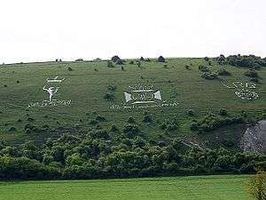
The Fovant Badges are a set of regimental badges cut into a chalk hill, Fovant Down, near Fovant, in southwest Wiltshire, England. They are located between Salisbury and Shaftesbury on the A30 road in the Nadder valley; or approximately 1⁄2 mile (800 m) southwest of Fovant. They were created by soldiers garrisoned nearby, and waiting to go to France, during the First World War; the first in 1916.[1] They are clearly visible from the A30 road which runs through the village. Nine of the original twenty remain, and are scheduled ancient monuments and recognised by the Imperial War Museum as war memorials.[1] Further badges have been added more recently.
The Fovant Badge Society holds an annual Drumhead Service which is attended by the Australian High Commissioner, local mayors and members of parliament. These services fund the upkeep of the badges.
Construction
After the outlines were cut into the grass-covered hillsides, they were refilled with chalk brought from a nearby slope, up to 50 tons per badge.[1] The badges took an average fifty men six months to complete.[1]
The badges
Current badges
Reading left to right (north-east to south-west), the badges at Fovant are:[2]
- Royal Wiltshire Yeomanry (only central part remaining)[3]
- YMCA, restored in 2018.[4]
- 6th (City of London) Battalion, London Regiment (City of London Rifles) (claimed to be the first of the badges cut here)[5][6]
- Australian Commonwealth Military Forces (the largest, 51m×32m)[7]
- Royal Corps of Signals (cut in 1970 to commemorate the Corps' 50th anniversary)[8]
- Wiltshire Regiment (added in 1950)[9]
- 5th (City of London) Battalion, London Regiment (London Rifle Brigade)[10]
- 8th (City of London) Battalion, London Regiment (Post Office Rifles)[11]
- Devonshire Regiment[12]
Centenary badge
To commemorate the centenary of the first badge, created in 1916, a badge in the shape of a poppy, to represent the poppies that grew in “Flanders Fields” has been created.[13][14]
Lost badges
Several of the lost badges were short lived, small and crudely constructed.
- Royal Army Service Corps[15]
- Royal Army Medical Corps, possibly on the site of where Royal Wiltshire Yeomanry is now.[15]
- Machine Gun Corps[15]
- Queen Victoria's Rifles[15]
- 35th Training Battalion[15]
- 'Dingo'[15]
- Post Office Rifles 'POR' letters, possibly there prior to the current Post Office Rifles figure.[15]
- 7th Battalion of the City of London Regiment (there is also a figure for this Regiment in Sutton Mandeville)[15]
- 9th Royal Berkshire Regiment[15]
- 37th Training Battalion[15]
- Voluntary Aid Detachment[15]
Nearby badges

The previously unrestored military badge at Sutton Down of the Royal Warwickshire Regiment was restored during 2017 and spring 2018 by volunteers of the Sutton Mandeville Heritage Trust. It was supported by a grant from the National Lottery and the restored badge was inaugurated on 3 May 2018 by Prince Edward, Duke of Kent, Colonel-in-Chief of the Royal Regiment of Fusiliers, the successor to the Royal Warwickshire Regiment. (51°02′34″N 2°01′29″W / 51.042847°N 2.024854°W)[16]
The nearby badge of 7th Battalion, The London Regiment remains unrestored. (51°02′32″N 2°01′21″W / 51.042226°N 2.022386°W)
After more than twenty years of neglect the outline map of Australia on Compton Down has been restored by a local voluntary group called the Map of Australia Trust (MOAT).[17] This unique hill figure was created by Australian troops garrisoned in Hurdcott Camp in the fields below the map training and awaiting transport to the battlefields of WW1. The map is a Scheduled Monument.[18] (51°03′43″N 1°56′24″W / 51.061816°N 1.939990°W)
On Lamb Down, on the north side of the A36 between Codford and the Deptford interchange and about 9 miles north by west of Fovant, is a cutting of the Australian Commonwealth Military Force badge, it is less detailed than the one at Fovant. It was cut in 1916–1917. (51°03′54″N 1°47′51″W / 51.064944°N 1.79738°W)
Additionally, near Barford St Martin, at the eastern end of the Fovant Encampment, was the Finsbury Rifles Badge. Not much is known about this figure.[19]
Also about 20 miles distance of the Fovant Badges is another military hill figure, though not of a badge: the Bulford Kiwi, which resides in the grounds of the Bulford Camp.[20]
References
- 1 2 3 4 "06/11/2011, Countryfile - BBC One". BBC.
- ↑ Bing aerial imagery, accessed 7 November 2011
- ↑ "Royal Wiltshire Yeomanry Badge". Fovant Badges Society. Retrieved 7 November 2011.
- ↑ Falcke, David (8 Sep 2018). "Bulford-based Rifles recut new YMCA Fovant badge". Salisbury Journal. Retrieved 7 Oct 2018.
- ↑ "The 6th City of London Regiment Badge". Fovant Badges Society. Retrieved 7 November 2011.
- ↑ Capt E.G. Godfrey, The "Cast Iron Sixth": A History of the Sixth Battalion London Regiment (The City of London Rifles), London: Old Comrades' Association, 1935//Uckfield: Naval & Military Press, 2002, ISBN 1-84342-170-4.
- ↑ "Australian Imperial Force Badge". Fovant Badges Society. Retrieved 7 November 2011.
- ↑ "Royal Corps of Signals Badge". Fovant Badges Society. Retrieved 7 November 2011.
- ↑ "Wiltshire Regiment Badge". Fovant Badges Society. Retrieved 7 November 2011.
- ↑ "London Rifle Brigade Badge". Fovant Badges Society. 13 May 1915. Retrieved 7 November 2011.
- ↑ "Post Office Rifles Badge". Fovant Badges Society. Retrieved 7 November 2011.
- ↑ "Devonshire Regiment Badge". Fovant Badges Society. Retrieved 7 November 2011.
- ↑ "Wiltshire hillside unveiling for giant carved Flanders Poppy". BBC. 28 October 2016.
- ↑ "Giant chalk poppy work begins at Fovant Down". BBC News. 4 July 2016.
- 1 2 3 4 5 6 7 8 9 10 11 Hows, Mark. "Lost Fovant Down Military Badges". www.hows.org.uk.
- ↑ "Re-carved Sutton Badge gets Royal seal of approval". Spire FM. 4 May 2018. Retrieved 4 June 2018.
- ↑ Griffin, Katy (9 Oct 2018). "Chalk badge restored for future generations". Salisbury Journal. Retrieved 9 Oct 2018.
- ↑ "Chalk map of Australia 925m south west of Upper Hurdcott Farm". Historic England Archives. 1 June 2001. Retrieved 10 Oct 2018.
- ↑ Hows, Mark. "Hurdcott Badge". www.hows.org.uk.
- ↑ Historic England. "Kiwi Chalk Figure above Bulford Camp (1443438)". National Heritage List for England. Retrieved 13 November 2017.
External links
| Wikimedia Commons has media related to Fovant Badges. |