Fortun (village)
| Fortun | |
|---|---|
| Village | |
 View of the village area | |
 Fortun Location in Sogn og Fjordane county  Fortun Fortun (Norway) | |
| Coordinates: 61°29′42″N 07°41′19″E / 61.49500°N 7.68861°ECoordinates: 61°29′42″N 07°41′19″E / 61.49500°N 7.68861°E | |
| Country | Norway |
| Region | Western Norway |
| County | Sogn og Fjordane |
| District | Sogn |
| Municipality | Luster Municipality |
| Elevation[1] | 34 m (112 ft) |
| Time zone | UTC+01:00 (CET) |
| • Summer (DST) | UTC+02:00 (CEST) |
| Post Code | 6877 Fortun |
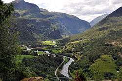
Fortun is a village in Luster Municipality in Sogn og Fjordane county, Norway. The village is located in the Fortundalen valley, just east of Skjolden, at the innermost part of the Lustrafjorden. The Sognefjellsvegen road passes through the village. Fortun is an old church site, having a stave church on the site since the 12th century. The present Fortun Church was built in 1879 in the village, and it serves the eastern part of the municipality. The Hurrungane mountains lie just to the south of the village. The area is known for its scenery and attracts many tourists.[2]
References
This article is issued from
Wikipedia.
The text is licensed under Creative Commons - Attribution - Sharealike.
Additional terms may apply for the media files.