Fortifications of Derbent
| UNESCO World Heritage site | |
|---|---|
 Wall of the Derbent citadel | |
| Criteria | Cultural: iii, iv |
| Reference | 1070 |
| Inscription | 2003 (27th Session) |
| Area | 9.7 ha |
| Buffer zone | 2 ha |
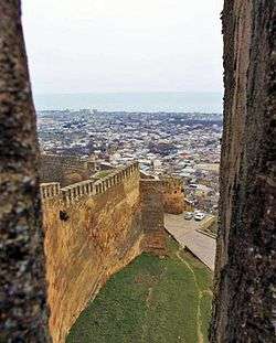
The Fortifications of Derbent are one of the fortified defense lines built by the Sasanian Empire to protect the eastern passage of the Caucasus Mountains (the "Caspian Gates") against the attacks of the nomadic peoples of the Pontic–Caspian steppe. Built in the 6th century and maintained by various later regimes, the fortifications comprise three distinct elements: the citadel of Naryn-Kala at Derbent, the twin long walls connecting it with the Caspian Sea in the east, and the "mountain wall" of Dagh-Bary, running from Derbent to the Caucasus foothills in the west. The fortification complex was made a UNESCO World Heritage Site in 2003.
Background and first fortifications at Derbent
Already in Classical Antiquity, the settlement of Derbent and its wider region (the "Caspian Gates") were known for their strategic location between the Caspian Sea and the eastern foothills of the Caucasus Mountains, separating the settled regions south of the Caucasus from the nomadic peoples dominating the Pontic–Caspian steppe to the north.[1] Archaeological evidence points to the establishment of a fortified settlement on the Derbent hill as early as the late 8th century BCE, probably under the impact of Scythian raids. This settlement initially covered only the more protected northeastern side of the hill (some 4–5 hectares), but over the 6th–4th centuries BCE expanded to cover its entire surface (c. 15 hectares). The walls of that settlement were some 2 metres (6.6 ft) high and maximally 7 metres (23 ft) thick, with evidence of repeated destruction and rebuilding throughout the period.[1]
From the 4th century BCE, the settlement began to expand beyond the hill fortress, which became a citadel to an expanding city. In the 1st century BCE, Derbent became incorporated in the kingdom of Caucasian Albania, probably as its northernmost possession. Derbent experienced a period of considerable prosperity in the first three centuries of the Common Era, but the resumption of nomad raids in the 4th century (the Alans and later the Huns) meant that it quickly reverted to its role as a frontier post and a "symbolic boundary between nomadic and agrarian ways of life".[1] In the late 4th century CE, Albania passed under Sasanian influence and control; in the 5th century, it was a Sasanian border fortress and the seat of a march-warden (marzban).[1]
Later history
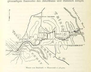 Map of the Sasanian fortifications at Derbent, by Roderich von Erckert
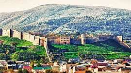 The citadel of Naryn-Kala and the walls of Derbent
References
- 1 2 3 4 Kettenhofen 1994.
Sources
- Gadjiev, M. S. (2008). "Даг-бары – Великая Кавказская стена". Дагестанские святыни (in Russian). II. Makhachkala: Epokha. pp. 8–36. ISBN 978-5-98390-051-6.
- Gadjiev, Murtazali (2017). "DAGH BARY". Encyclopædia Iranica, online edition.
- Kettenhofen, Erich (1994). "DARBAND". Encyclopædia Iranica. VII. pp. 13–19.