Fort Pitt Tunnel
 Northeast Portal of Fort Pitt Tunnel | |
| Overview | |
|---|---|
| Location | Pittsburgh, Pennsylvania |
| Coordinates |
763-4-1, 870+00 west portal 763-4-1, 912+25 east portal |
| Route |
|
| Start | I-376 Fort Pitt Bridge |
| End | US 19 |
| Operation | |
| Work begun | August 28, 1957 |
| Constructed | Twin bore, circular roof with an exposed curved ceiling, concrete with ceramic tile lining |
| Opened | September 1, 1960 |
| Owner | PennDOT |
| Operator | PennDOT |
| Traffic | Automobile |
| Toll | none |
| Vehicles per day | 107,000 |
| Technical | |
| Design engineer | Michael Baker, Jr.[1] |
| Length | 3,614 feet (1,102 m) |
| No. of lanes | 4 |
| Operating speed | 55 mph (89 km/h) |
| Tunnel clearance | 13.5 feet (4.1 m) |
| Width | 28 feet (8.5 m) |
| Grade | 2.5% (east to west) |
| Building details | |
| Design and construction | |
| Architect | Joseph Bontempo[1] |
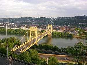
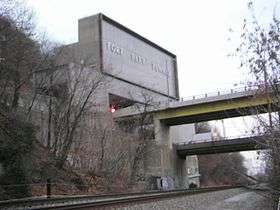
The Fort Pitt Tunnel carries traffic on Interstate 376 (I-376),[lower-alpha 1] U.S. Route 22 (US 22), US 30, and US 19 Truck between Downtown Pittsburgh and the West End neighborhood in the U.S. state of Pennsylvania. Traveling beneath Mount Washington, the structure is divided into a two lane inbound tunnel and two lane outbound tunnel. The inbound tunnel flows onto the top deck of the double-deck Fort Pitt Bridge, opposite traffic from the lower deck using the outbound tunnel. To accommodate the bridge, the northeast portals of the parallel tunnels open at two levels. "FORT PITT TUNNEL" is mounted in brushed steel letters on a grey granite facade above the southwest portals, with larger scaled capital letters used on the facade above the northeast portals.[1]
Before entering the southwest end of the inbound tunnel, travelers see a commonplace view of Southwestern Pennsylvania's hills, but at the northeast end, travelers emerge to a panorama of Pittsburgh's Golden Triangle and surrounding skyline, the view cited by The New York Times as "the best way to enter an American city". The vantage was the inspiration for the news opening on Pittsburgh's KDKA-TV for several years in the 1980s and 1990s,[2] and is referenced in Stephen Chbosky's novel The Perks of Being a Wallflower.
The Fort Pitt Tunnel opened in 1960, a year after the adjoining Fort Pitt Bridge.[1] It is the third longest automobile tunnel in the City of Pittsburgh, following the Liberty Tunnels and the Squirrel Hill Tunnel. And it is one of four major tunnels[lower-alpha 2] passing beneath Mount Washington, including the Liberty Tunnels and the Wabash Tunnel for automobiles, and the Mount Washington Transit Tunnel for public transportation.[3]
 |
.jpg) |
History
Before the existence of the Fort Pitt Tunnels (as well as the Penn Lincoln Parkway and West End Bypass), South Hills commuters travelled around the Banksville Circle, which was the northern terminus of Banksville Road and western terminus of Saw Mill Run Blvd at the time. On July 11, 1954, contracts were awarded for the basic design of the Fort Pitt Tunnels. The groundbreaking ceremony for the Fort Pitt tunnel was held April 17, 1957 and drilling began August 28 of the same year. In April 1960 construction on the tunnels was complete and they opened for the first time at 11 a.m. on September 1, 1960, with a dedication ceremony on the southwestern portal by Governor Lawrence, Pennsylvania Transportation Secretary Park H. Martin and Pittsburgh Mayor Joseph M. Barr followed by a "christening" of the tunnels in which the Governor led a caravan of antique cars through. The tunnel cost $17 million (equivalent to $141 million in 2017[4] ).[5][1][6][7]
On Thursday, May 31, 2007, a bomb threat shut down the Fort Pitt Tunnel along with the Liberty and Squirrel Hill tunnels, causing a major traffic jam.[8]
The tunnel provided AM reception in 1960, but due to design repairs it was discontinued until 1986. It was improved to cover the entire tunnel with strong reception in March 1997.[9] Since August 1987, the tunnels have provided cellular phone reception.[10] With the help of Carnegie Mellon University graduate students, the tunnel has provided FM reception since July 2005 as well as having its AM signals upgraded at that time. In 2015, the original flat ceiling was removed due to its poor condition.[11]
Dimensions and specifications
See also

Notes
- ↑ Interstate 279 prior to June 10, 2009
- ↑ Tunnels at least 3500 feet long
References
- 1 2 3 4 5 Lisa, Wardle (April 17, 2017). "Vintage photos of Fort Pitt Tunnel construction, which broke ground in 1957". Penn Live. Retrieved February 24, 2018.
- ↑ KDKA 5PM Anchor Rejoin (MAY 99) 10 Years Ago (Television production). Pittsburgh, Pennsylvania: KDKA-TV. May 1990. Retrieved February 23, 2018 – via YouTube.
- ↑ Grata, Joe (February 2016). "Underground Pittsburgh: Explore our City of Tunnels". Pittsburgh Magazine.
- ↑ Federal Reserve Bank of Minneapolis Community Development Project. "Consumer Price Index (estimate) 1800–". Federal Reserve Bank of Minneapolis. Retrieved January 2, 2018.
- ↑ "The new bridge opens". Pittsburgh Post-Gazette. June 19, 1959. p. 12. Retrieved February 24, 2018 – via Newspapers.com.
- ↑ Eskey, Kenneth (September 1, 1960). "New Tunnel Jams Bridge". The Pittsburgh Press. pp. 1, 3. Retrieved February 10, 2017 – via Google News.
- 1 2 3 Cridlebaugh, Bruce S. (September 10, 2001). "Fort Pitt Tunnel". Bridges and Tunnels of Allegheny County, Pennsylvania. Retrieved August 8, 2007.
- ↑ Ayad, Moustafa; Majors, Dan (June 1, 2007). "Bomb Threats Close Major Tunnels During downpour, Snarling Traffic Throughout City". Pittsburgh Post-Gazette.
- ↑ Grata, Joe (April 9, 1997). "Radio Reception in Parkway Tunnels Is Music to the Ears". Pittsburgh Post-Gazette. pp. A1, A2. Retrieved February 10, 2016 – via Google News.
- ↑ Bennett, Marcia (September 28, 1987). "Now It's Phones that Do Walking". Pittsburgh Post-Gazette. p. 23. Retrieved February 10, 2017 – via Google News.
- ↑ Ritchie, Jim (July 30, 2005). "Drivers No Longer Lo ..#!$.. adio Reception in Tunnels" (PDF). Pittsburgh Tribune-Review. Retrieved February 10, 2017.
External links
- Travel Channel video
- Video of the tunnel
- 40°25′55″N 80°01′28″W / 40.43191°N 80.02440°W - Southern portal
- 40°26′15″N 80°00′50″W / 40.43746°N 80.01394°W - Northern portal
Coordinates: 40°26′04″N 80°01′08″W / 40.43444°N 80.01889°W