Fort Kent–Clair Border Crossing
| Fort Kent–Clair Border Crossing | |
|---|---|
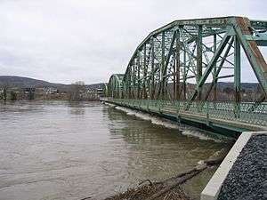 International Bridge between Fort Kent, Maine, and Clair, New Brunswick, during the flood of April 2008 | |
| Location | |
| Country | United States; Canada |
| Location |
US Port: 98 West Main Street, Fort Kent, Maine 04743 Canadian Port: 760 Rue Principale Clair, New Brunswick E7A 2H6 |
| Coordinates | 47°14′57″N 68°36′14″W / 47.249203°N 68.60389°W |
| Details | |
| Opened | 1905 |
| US Phone | (207) 834-5255 |
| Canadian Phone | (506) 992-2124 |
| Hours | Open 24 Hours |
|
Website http://www.cbp.gov/contact/ports/fort-kent | |
The Fort Kent - Clair Border Crossing is at the Clair–Fort Kent Bridge that connects the town of Fort Kent, Maine, with Clair, New Brunswick, on the Canada–United States border. It marks the northern terminus of U.S. Route 1. This crossing first opened in 1905 with the construction of a footbridge that traversed the Saint John River. A replacement for the steel bridge that was built in 1930 opened July 31, 2014.
The crossing is open 24 hours a day. About 2,000 cars use it a day.[1]
See also
References
- ↑ "Chapter 1: Northern Maine and New Hampshire". United Divide: A Linear Portrait of the USA/Canada Border. The Center for Land Use Interpretation. Winter 2015.
This article is issued from
Wikipedia.
The text is licensed under Creative Commons - Attribution - Sharealike.
Additional terms may apply for the media files.