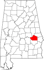
Fort Davis, Alabama
| Fort Davis, Alabama | |
|---|---|
| Unincorporated community | |
 Fort Davis, Alabama  Fort Davis, Alabama | |
| Coordinates: 32°14′36″N 85°42′35″W / 32.24333°N 85.70972°WCoordinates: 32°14′36″N 85°42′35″W / 32.24333°N 85.70972°W | |
| Country | United States |
| State | Alabama |
| County | Macon |
| Elevation | 312 ft (95 m) |
| Time zone | UTC-6 (Central (CST)) |
| • Summer (DST) | UTC-5 (CDT) |
| ZIP code | 36031 |
| Area code(s) | 334 |
| GNIS feature ID | 118517[1] |
Fort Davis is an unincorporated community in Macon County, Alabama, United States, located on U.S. Route 29, 12.9 miles (20.8 km) south of Tuskegee. Fort Davis has a post office with ZIP code 36031, which opened on June 4, 1891.[2][3]
History
Though it is easily assumed that the town had a military basis, it was actually named for one of its founders, a man whose first/given name was Fort and last name/surname was Davis. Richard T. Davis married Mary C. Fort and their first son was named for his mother's family. When the Seaboard Railroad came through the area, Fort M. Davis and his brother Hubert T. Davis laid out the town into lots and originally named it "Hamilton", but that was changed to "Fort Davis" to honor the founder. Fort M. Davis was also the first postmaster.
References
- ↑ "Fort Davis". Geographic Names Information System. United States Geological Survey.
- ↑ United States Postal Service (2012). "USPS - Look Up a ZIP Code". Retrieved 2012-02-15.
- ↑ "Postmaster Finder - Post Offices by ZIP Code". United States Postal Service. Retrieved June 5, 2013.
- Smith, Virginia (1974-04-18). "Fort Davis Never a Fort; Named for a Man". Columbus (Georgia) Ledger-Enquirer East Alabama TODAY. Page 8.
