Fort-Mardyck
Coordinates: 51°01′52″N 2°18′22″E / 51.031°N 2.3061°E
.jpg)
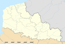
Fort-Mardyck (Dutch: Fort-Mardijk) is a former commune in the Nord department in northern France. Since 9 December 2010, it is part of the commune of Dunkirk.[1][2] In 1999 it had 3,770 inhabitants.
History
The fort of Mardyck was constructed in 1622 by architect Jean Gamel. It was built for the Spanish who ruled Flanders at the time. The fort was captured by the French in 1644 but then lost to the Spanish in 1652. The fort was again besieged and captured by an Anglo-French force under the Comte de Turrenne on 21 September 1657. Turrene handed the fort over to the English Commonwealth in accordance with the terms of their involvement. The following month the Spanish attempted to retake the fort one last time but the English garrison managed to repel the assault.[3] After having bought Dunkirk and the fort of Mardyck from the English in 1662, King Louis XIV of France ordered that the fort be dismantled.
On 12 February 1867, a French imperial decree established Fort-Mardyck as an independent municipality.
Heraldry

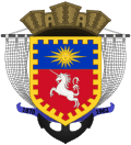 |
The arms of Fort-Mardyck are blazoned : Gules, unicorn salient argent, on a chief a sun in her splendour, all within a bordure Or. (The emblazon shows a per fess field, which would make more sense, rather than a field and chief...) |
References
- ↑ La Voix du Nord Archived 2011-05-25 at the Wayback Machine. 8 December 2010
- ↑ INSEE
- ↑ Plant, David. "The Anglo-Spanish War: Overview Cromwell's Protectorate in alliance with France against Spain". Flanders 1657-8, BCW Project.
External links
| Wikimedia Commons has media related to Fort-Mardyck. |