Forest, Guernsey
| Forest | |
|---|---|
| Parish | |
.jpg) Ste Marguerite de la Foret parish church | |
.GIF) Location of Forest in Guernsey | |
| Coordinates: 49°25′33″N 2°35′51″W / 49.4258°N 2.5976°WCoordinates: 49°25′33″N 2°35′51″W / 49.4258°N 2.5976°W | |
| Crown Dependency | Guernsey, Channel Islands |
| Government | |
| • Electoral district | West |
| Area | |
| • Total | 4.2 km2 (1.6 sq mi) |
| Population | |
| • Total | 1,549 |
| • Density | 370/km2 (960/sq mi) |
| Time zone | GMT |
| • Summer (DST) | UTC+01 |
The Forest (Guernésiais: La Fouarêt, French La Forêt) is a parish in Guernsey. It is the highest parish on the island, with altitudes of up to about 100 m. The full title of the parish is Ste Marguerite de la Foret, after the parish church.
The old Guernésiais nickname for people from La Fouarêt was bourdaons.
The postal codes for street addresses in this parish begin with GY8.
Forest was the first parish in the Island to receive some unwelcome visitors. Chief Officer Inspector W Sculpher recorded the following in the Occurrence Book dated Wednesday, 3 July 1940: "I beg to report that at about 8pm on 30th June a number of German Armed Forces landed at the Airport, Forest."[1]
Geography
The Forest is located in the south of Guernsey. It borders the parishes of St Peter's to the west, St Saviour's to the north-west, St Andrew's to the north and St Martin's to the east.
Beaches The south coast is mostly made up of cliffs, but the beaches in The Forest include:
- Le Portelet (inaccessible from land; it can be accessed by swimming from Petit Bôt or by boat)
- Part of Petit Bôt
Relief The parish goes up to an altitude of about 100 m (the highest in the island). The only low areas are at the coast, where there are steep cliffs.
Climate
The Meteorological Observatory has been at Guernsey Airport since it was built in 1939.[2]
| Climate data for Forest, Guernsey (Guernsey Airport) | |||||||||||||
|---|---|---|---|---|---|---|---|---|---|---|---|---|---|
| Month | Jan | Feb | Mar | Apr | May | Jun | Jul | Aug | Sep | Oct | Nov | Dec | Year |
| Record high °C (°F) | 13.3 (55.9) |
15.0 (59) |
19.4 (66.9) |
24.3 (75.7) |
25.9 (78.6) |
30.8 (87.4) |
31.7 (89.1) |
34.3 (93.7) |
30.6 (87.1) |
23.6 (74.5) |
16.8 (62.2) |
15.6 (60.1) |
34.3 (93.7) |
| Average high °C (°F) | 8.7 (47.7) |
8.4 (47.1) |
10.0 (50) |
11.8 (53.2) |
14.9 (58.8) |
17.5 (63.5) |
19.5 (67.1) |
19.8 (67.6) |
18.0 (64.4) |
15.1 (59.2) |
11.8 (53.2) |
9.5 (49.1) |
13.8 (56.8) |
| Daily mean °C (°F) | 6.9 (44.4) |
6.5 (43.7) |
7.8 (46) |
9.2 (48.6) |
12.1 (53.8) |
14.5 (58.1) |
16.6 (61.9) |
17.0 (62.6) |
15.5 (59.9) |
13.0 (55.4) |
10.0 (50) |
7.8 (46) |
11.4 (52.5) |
| Average low °C (°F) | 5.0 (41) |
4.6 (40.3) |
5.6 (42.1) |
6.6 (43.9) |
9.2 (48.6) |
11.5 (52.7) |
13.6 (56.5) |
14.1 (57.4) |
12.9 (55.2) |
10.8 (51.4) |
8.1 (46.6) |
6.0 (42.8) |
9.0 (48.2) |
| Record low °C (°F) | −7.8 (18) |
−7.2 (19) |
−2.2 (28) |
−1.4 (29.5) |
0.1 (32.2) |
5.4 (41.7) |
8.3 (46.9) |
9.2 (48.6) |
5.8 (42.4) |
3.5 (38.3) |
−0.8 (30.6) |
−3.8 (25.2) |
−7.8 (18) |
| Average precipitation mm (inches) | 92.5 (3.642) |
70.2 (2.764) |
67.0 (2.638) |
53.1 (2.091) |
50.9 (2.004) |
45.5 (1.791) |
42.1 (1.657) |
47.7 (1.878) |
57.5 (2.264) |
95.0 (3.74) |
104.3 (4.106) |
112.9 (4.445) |
838.7 (33.02) |
| Average precipitation days (≥ 0.2 mm) | 19.3 | 15.7 | 15.9 | 13.2 | 11.9 | 10.4 | 11.0 | 10.6 | 12.4 | 17.3 | 18.8 | 18.6 | 175.0 |
| Average snowy days | 2.8 | 4.0 | 1.3 | 0.6 | 0.0 | 0.0 | 0.0 | 0.0 | 0.0 | 0.0 | 0.5 | 1.7 | 11.0 |
| Mean monthly sunshine hours | 61.0 | 85.6 | 127.6 | 194.7 | 234.5 | 246.6 | 250.7 | 230.1 | 180.1 | 117.1 | 77.8 | 58.2 | 1,864 |
| Percent possible sunshine | 22.7 | 29.1 | 34.7 | 47.7 | 49.6 | 51.2 | 51.7 | 52.0 | 47.8 | 35.3 | 28.7 | 22.8 | 41.8 |
| Source: Guernsey Met Office 2014 Weather Report [3] | |||||||||||||
Features
|
The features of the parish include:
|
The parish of the Forest hosts:
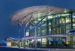 Guernsey Airport terminal
|
Main roads
.jpg)
The following main roads (listed from West-East) provide important links between The Forest and the other parishes:
- Rue De Manoir (leads to Torteval)
- Rue De Farras (leads to St Peter's)
- Route Des Blicqs (leads to St Andrew's, St Peter Port and the North of the island)
- Forest Road (leads to St Martin's)
The following main roads (listed from West-East) are also very important as they provide access to the Parish Centre and the Airport:
- Rue Des Landes
- Le Bourg
Politics
Forest comprises part of the West administrative division with Torteval, St. Saviour's and St. Pierre-du-Bois
In the Guernsey general election, 2016 there was a 3,188 or 74% turnout to elect five Deputies. Those elected (in order of votes received) being Al Brouard, Andrea Dudley-Owen, Emilie Yerby, David De Lisle and Shane Langlois.
Notable people
- Ernest Martin Jehan, Royal Navy officer during World War I
- Thomas de la Rue, founder of De La Rue plc
- William Le Lacheur, sea captain with strong links to Costa Rica
References
- ↑ "HISTORY OF THE GUERNSEY POLICE".
- ↑ "History of the Guernsey Met Office". Met Office Guernsey.
- ↑ "2014 Weather Report" (PDF). Guernsey Met Office.
- ↑ "Petit Bot to Le Gouffre and back". Guernsey Walker.
- ↑ "Petit Bot Bay". Good Beach Guide.
- 1 2 3 Dillon, Paddy. Channel Island Walks. Cicerone Press Limited, 1999. ISBN 9781852842888.
- ↑ "Guernsey airport".
- ↑ "Le Perron du Roi". megalithicguernsey.
- ↑ "Forest Parish Memorial, Guernsey". Great War CI.
- ↑ "Occupation Museum".
- ↑ "Guernsey Abreuvoirs". La Société Guernesiaise.
- ↑ "PROTECTED BUILDINGS". Environment – Guernsey government.
- ↑ "Contact us Archived 7 July 2011 at the Wayback Machine.." Aurigny Air Services. Retrieved on 12 February 2011. "Aurigny Air Services Ltd States Airport La Planque Lane Forest Guernsey, GY8 OTD Channel Islands."
- ↑ "The Mallard Cinema".
External links
| History |  | ||||
|---|---|---|---|---|---|
| Subdivisions |
| ||||
| Schools |
| ||||
| Politics | |||||
| Economy |
| ||||
| Culture |
| ||||
| |||||