Fordham, Essex
Fordham is a village and civil parish in the Colchester district of the English county of Essex, six miles north-west of the town of Colchester. It has a population measured at 835 in the 2011 Census.[1] The parish includes the nearby hamlets of Fordham Heath and Hemp's Green.
Governance
Fordham is part of the electoral ward of Fordham and Stour Valley. The population of the ward at the 2011 census was 5,332.[2]
Natural features
Fordham is bounded to the south by the River Colne. An area of 500 acres (202 ha) in the parish was turned over to the Woodland Trust in 2001 for future woodland.[3]
Amenities and events
The village has a post office and a historic pub called The Three Horseshoes. Another pub, The Shoulder of Mutton is also in Fordham parish. It stands on the main Colchester–Halstead Road, near the bridge over the Colne replacing the ford that gave the hamlet of Fordstreet its name.
Fordham offers primary education at All Saints Church of England Primary School.[3]
The village hosts a fair every year on the first Saturday of July, and a vehicle show on the second Sunday of August.
Places of worship
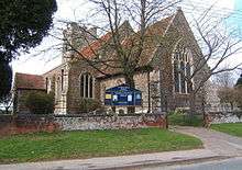
All Saints' Church dates from about 1340 and is a Grade I listed building dating mainly from the 14th century.[4] There was a chapel of the Countess of Huntingdon's Connexion in the village in the 19th century.[5]
Notable people
In birth order:
- Roger Walden (died 1406) held Fordham as one of several church benefices. He was later briefly Archbishop of Canterbury, then Bishop of London.[6]
- John Owen (1616–1683), a Nonconformist, held the benefice of Fordham in 1642–46 as a Calvinist, but was not then appointed rector.[7]
- Thomas Twining (1735–1804), a noted classical scholar and a member of the tea-merchant family, held the curacy of the church from 1764 until his death.[8]
- Digger Kettle (1922–1999), a professional footballer who appeared 145 times for Colchester United, died in Fordham.
References
- ↑ "Civil Parish population 2011". Retrieved 29 September 2015.
- ↑ "Fordham and Stour Valley ward population 2011". Retrieved 29 September 2011.
- 1 2 Village site Retrieved 5 June 2018.
- ↑ Historic England. "CHURCH OF ALL SAINTS (1239789)". National Heritage List for England. Retrieved 21 April 2014.
- ↑ A Vision of Britain through Time. Retrieved 5 June 2018.
- ↑ Pat Lewis: All Saints Church, Fordham, Essex. Notes on the Rectors, 2009 Retrieved 5 June 2018.; Fryde Handbook of British Chronology, p. 233.
- ↑ Chisholm, Hugh, ed., "Owen, John". Encyclopædia Britannica 20 (11th ed.) Cambridge University Press, 1911, pp. 392–393.
- ↑ ODNB entry: Retrieved 26 June 2011. Subscription required.
Coordinates: 51°55′22″N 0°48′13″E / 51.9228°N 0.8035°E