Forbidden Glacier
| Forbidden Glacier | |
|---|---|
 Forbidden Glacier | |
 Forbidden Glacier Location in Washington | |
| Type | Mountain glacier |
| Location | North Cascades National Park, Skagit County, Washington, U.S. |
| Coordinates | 48°31′03″N 121°03′44″W / 48.51750°N 121.06222°WCoordinates: 48°31′03″N 121°03′44″W / 48.51750°N 121.06222°W[1] |
| Length | .75 mi (1.21 km) |
| Terminus | Icefall/barren rock |
| Status | Retreating |
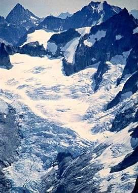
Forbidden Glacier is on the north slopes of Forbidden Peak, North Cascades National Park in the U.S. state of Washington.[2] The glacier is approximately .75 mi (1.21 km) in length, 1 mi (1.6 km) in width at its terminus and descends from 8,000 to 5,600 ft (2,400 to 1,700 m). The glacier is separated by an arête from Boston Glacier to the east and south. Meltwaters from Forbidden Glacier flow into Moraine Lake.
See also
References
- ↑ "Forbidden Glacier". Geographic Names Information System. United States Geological Survey. Retrieved 2013-02-09.
- ↑ Forbidden Peak, WA (Map). TopoQwest (United States Geological Survey Maps). Retrieved 2013-02-09.
This article is issued from
Wikipedia.
The text is licensed under Creative Commons - Attribution - Sharealike.
Additional terms may apply for the media files.