Footscray railway station
Footscray | ||||||||||||||||||||||||||||||||||||||
|---|---|---|---|---|---|---|---|---|---|---|---|---|---|---|---|---|---|---|---|---|---|---|---|---|---|---|---|---|---|---|---|---|---|---|---|---|---|---|
| Commuter and regional rail station | ||||||||||||||||||||||||||||||||||||||
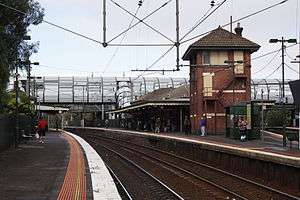 Looking south from platform 6 in April 2010, with disused signal box on platform 5 in the foreground | ||||||||||||||||||||||||||||||||||||||
| Location |
Irving Street, Footscray Australia | |||||||||||||||||||||||||||||||||||||
| Coordinates | 37°48′06″S 144°54′09″E / 37.8016°S 144.9024°ECoordinates: 37°48′06″S 144°54′09″E / 37.8016°S 144.9024°E | |||||||||||||||||||||||||||||||||||||
| Owned by | VicTrack | |||||||||||||||||||||||||||||||||||||
| Operated by | Metro Trains | |||||||||||||||||||||||||||||||||||||
| Line(s) |
Sunbury Werribee Williamstown Serviceton Port Fairy | |||||||||||||||||||||||||||||||||||||
| Distance | 5.62 kilometres from Southern Cross | |||||||||||||||||||||||||||||||||||||
| Platforms | 6 (2 side, 2 island) | |||||||||||||||||||||||||||||||||||||
| Tracks | 6 | |||||||||||||||||||||||||||||||||||||
| Connections |
Bus Tram | |||||||||||||||||||||||||||||||||||||
| Construction | ||||||||||||||||||||||||||||||||||||||
| Structure type | Ground | |||||||||||||||||||||||||||||||||||||
| Disabled access | Yes | |||||||||||||||||||||||||||||||||||||
| Other information | ||||||||||||||||||||||||||||||||||||||
| Status | Premium station | |||||||||||||||||||||||||||||||||||||
| Station code | FSY | |||||||||||||||||||||||||||||||||||||
| Fare zone | 1 | |||||||||||||||||||||||||||||||||||||
| Website | Public Transport Victoria | |||||||||||||||||||||||||||||||||||||
| History | ||||||||||||||||||||||||||||||||||||||
| Opened | 17 January 1859 | |||||||||||||||||||||||||||||||||||||
| Rebuilt | 2014 | |||||||||||||||||||||||||||||||||||||
| Electrified | Yes | |||||||||||||||||||||||||||||||||||||
| Traffic | ||||||||||||||||||||||||||||||||||||||
| Passengers (2008-2009) | 3.705 million[1] | |||||||||||||||||||||||||||||||||||||
| Passengers (2009-2010) |
3.648 million[1] | |||||||||||||||||||||||||||||||||||||
| Passengers (2010-2011) |
3.856 million[1] | |||||||||||||||||||||||||||||||||||||
| Passengers (2011-2012) |
4.199 million[1] | |||||||||||||||||||||||||||||||||||||
| Passengers (2012-2013) | Not measured[1] | |||||||||||||||||||||||||||||||||||||
| Passengers (2013-2014) |
3.767 million[1] | |||||||||||||||||||||||||||||||||||||
| Services | ||||||||||||||||||||||||||||||||||||||
| ||||||||||||||||||||||||||||||||||||||
Footscray railway station is located on the Sunbury, Werribee and Williamstown lines, in Victoria, Australia. It serves the western Melbourne suburb of Footscray, and opened on 17 January 1859.[2][3]
It is also serviced by V/Line Ballarat, Bendigo and Geelong services. In 2011/12, it was the sixth busiest station on Melbourne's metropolitan network, with 4.2 million passenger movements recorded.[4]
A disused signal box is located on the island platform at the Up (Flinders Street) end of Platform 5, while a pair of dual gauge tracks form the mainly freight only South Kensington-West Footscray line under the station, running in a cutting before entering the Bunbury Street tunnel,[5] providing a rail link to the Port of Melbourne and other freight terminals, as well as access to Southern Cross for the NSW TrainLink XPT, The Overland, and V/Line Albury services.
History
On 17 January 1859, the railways arrived in Footscray, when the new Williamstown line opened, with trains running from Spencer Street in Melbourne to the important cargo port of Williamstown. This railway line connected to the 18-month-old Geelong railway at the junction near where the current Newport station lies.[6] The line between Melbourne and Footscray, via the new station at North Melbourne, had been made possible with the construction of a railway bridge over the Maribyrnong River. The first station to open in Footscray opened on this line on the opening day of service; it was not, however, where the current Footscray station lies, but was located on Napier Street.
Shortly afterwards, Footscray became a junction station, when a second railway line, branching at Footscray, was opened to Sunbury. By 1862, this railway line had been extended to Sandhurst (later renamed Bendigo). Therefore, on 1 March 1859, less than two months after the first, Footscray's second railway station opened on Nicholson Street, not far from the original Napier Street location, for services on the new railway line.[7] A signal box was provided at the junction from 1879.
On 16 September 1900, the current station opened, located at the precise point of junction of the two lines.[8] The two original stations were then closed.[7]
A number of sidings once existed at the station, now covered by car parking on the eastern side of the Newport bound lines.
The dual gauge tracks under the station were opened on 21 October 1928, as part of the South Kensington-West Footscray line, and were dual-gauged in the early 1960s, as part of the construction of the Melbourne-Albury standard gauge line. Quadruplication of the tracks towards Melbourne in November 1976 put an end to the junction and closed the signal box. The building is listed on the Victorian Heritage Register.
It was upgraded to a Premium station on 31 May 1996, although the enclosed waiting area and ticket facilities were built in 1993, as part of the 'Travel Safe' program in the early 1990s.[9]
On 5 June 2001, at around 08:30, two suburban Comeng trains collided on Platform 4. An out of service train heading to Newport collided with a Williamstown bound train, carrying around 20 passengers, with 3 injuries reported.[10]
In 2010, as a part of the Brumby State Government's Footscray renewal program,[11] the existing footbridge over the platforms, which was accessed by ramps, was replaced with a $15 million footbridge. The bridge, named after indigenous activist William Cooper,[12] has stairs and associated lifts. Complaints have been made that the new footbridge is less usable than the one it replaced. It has a roof, but that has not been designed to be weatherproof, and the lifts are prone to breakdown.[13]
2012-2014 Regional Rail Link Upgrade and Conservation Works
From 2012-2014, Footscray station underwent major upgrade and conservation works as part of the Regional Rail Link project.
An additional two platforms were built to the north of the existing platforms, to separate Metro Trains Sunbury services from V/Line services to Ballarat, Bendigo and Geelong. In January 2014, Platforms 1 to 4 were renumbered 3 to 6, with the new platforms commissioned as Platforms 1 and 2.[14] At the same time, Platforms 3 and 4 were closed to be rebuilt as dedicated platforms for V/Line services, reopening in July 2014.
The existing footbridge, erected in 2010 at a cost of $15 million, was also partially demolished in 2013 to help accommodate the works. [15] New canopies, stairs and escalators were erected at the Irving and Hyde St ends of the footbridge, and new ramps were built in 3 spots off the right side of the bridge, to help people access the platforms more easily. New lifts were also added to the structure.
Platforms & services
Footscray has six platforms. It is serviced by Metro Trains' Sunbury, Werribee and Williamstown services[16][17][18] and V/Line Ballarat, Bendigo and Geelong services.[19][20][21]
Platform 1:
- Sunbury line: services to Flinders Street
Platform 2:
- Sunbury line: all stations and limited stops services to Sunbury
Platform 3:
- Ballarat line: V/Line services to Southern Cross
- Ararat line: V/Line services to Southern Cross
- Bendigo line: V/Line services to Southern Cross
- Echuca line: V/Line services to Southern Cross
- Swan Hill line: V/Line services to Southern Cross
- Geelong line: V/Line services Southern Cross
- Warrnambool line: V/Line services Southern Cross
Platform 4:
- Ballarat line: V/Line services to Ballarat
- Ararat line: V/Line services to Ararat
- Bendigo line: V/Line services to Bendigo
- Echuca line: V/Line services to Echuca
- Swan Hill line: V/Line services to Swan Hill
- Geelong line: V/Line services to Wyndham Vale, Geelong & Waurn Ponds
- Warrnambool line: V/Line services to Warrnambool
Platform 5:
- Werribee line: all stations and limited stops services to Flinders Street
- Williamstown line: weekday all stations and limited stops services to Flinders Street
Platform 6:
- Werribee line: all stations and limited stops services to Werribee
- Williamstown line: weekday all stations and limited stops services to Williamstown
Transport links
CDC Melbourne operates six routes via Footscray station:
- 406: to Keilor East[22]
- 409: Yarraville – Highpoint Shopping Centre[23]
- 410: to Sunshine station[24]
- 411: to Laverton station[25]
- 412: to Laverton station[26]
- 414: to Laverton station[27]
Sita Buslines operates four routes via Footscray station:
- 402: to East Melbourne[28]
- 403: to University of Melbourne Parkville Campus[29]
- 404: to Moonee Ponds Junction[30]
- 472: Williamstown – Moonee Ponds Junction[31]
Transdev Melbourne operates four routes via Footscray station:
- 216: Caroline Springs – Brighton Beach station[32]
- 219: Sunshine South – Gardenvale[33]
- 220: Sunshine station – Gardenvale[34]
- 223: Yarraville – Highpoint Shopping Centre[35]
Yarra Trams operates one route to and from Footscray station:
Gallery
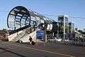 Footbridge that links all platforms taken from Irving Street in December 2011
 The same view from Irving Street in May 2014
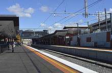 Westbound view from Platform 2 in May 2014
.jpg) The South Kensington - West Footscray railway line cutting runs beneath the south-western end of Platforms 5 and 6 in September 2008
The South Kensington - West Footscray railway line cutting runs beneath the south-western end of Platforms 5 and 6 in September 2008
References
- 1 2 3 4 5 6 "Train Station Patronage FY2008-2014" (XLS). Public Transport Victoria. 14 May 2015. Archived from the original on 30 March 2016. Retrieved 1 November 2016. (access from )
- ↑ Footscray Vicsig
- ↑ Footscray Station Rail Geelong
- ↑ Station Patronage Research Public Transport Victoria
- ↑ Lucas, Clay (2010-06-15). "$4.3b link won't cut travel times". The Age. Retrieved 2013-02-19.
- ↑ "Rail Geelong - Geelong Line History". railgeelong.com. Retrieved 2009-09-08.
- 1 2 Infrastructure - Footscray Vicsig
- ↑ "The New Footscray Railway Station". The Independent. 9 December 1899. p. 3.
- ↑ "Upgrading Eltham to a Premium Station". Newsrail. Australian Railway Historical Society. October 1997. p. 310.
- ↑ "Operations". Newsrail. Australian Railway Historical Society. July 2001. p. 218.
- ↑ "Transport Projects eNews". Department of Transport, Victoria. Retrieved 2013-01-19.
- ↑ Lucas, Clay (2 November 2010). "The great disconnect". The Age. Melbourne.
- ↑ "Colander Bridge". Fair-go for Footscray Rail Residents. Retrieved 2013-02-19.
- ↑ Major access changes V/Line January 2014
- ↑ Millar, Benjamin (2013-02-06). "Footscray commuters face long wait for station works completion". Maribyrnong Weekly. Retrieved 2013-02-19.
- ↑ Sunbury Line timetable Public Transport Victoria
- ↑ Werribee Line timetable Public Transport Victoria
- ↑ Williamstown Line timetable Public Transport Victoria
- ↑ Ballarat - Melbourne timetable Public Transport Victoria
- ↑ Bendigo - Melbourne timetable Public Transport Victoria
- ↑ Geelong - Melbourne timetable Public Transport Victoria
- ↑ Route 406 Keilor East - Footscray timetable Public Transport Victoria
- ↑ Route 409 Yarraville - Shopping Centre timetable Public Transport Victoria
- ↑ Route 410 Sunshine - Footscray timetable Public Transport Victoria
- ↑ Route 411 Laverton - Footscray timetable Archived 13 April 2014 at the Wayback Machine. Public Transport Victoria
- ↑ Route 412 Laverton - Footscray timetable Archived 13 April 2014 at the Wayback Machine. Public Transport Victoria
- ↑ Route 414 Laverton - Footscray timetable Archived 11 April 2014 at the Wayback Machine. Public Transport Victoria
- ↑ Route 402 Footscray - East Melbourne timetable Archived 11 April 2014 at the Wayback Machine. Public Transport Victoria
- ↑ Route 403 Footscray - University of Melbourne timetable Public Transport Victoria
- ↑ Route 404 Footscray - Moonee Ponds timetable Public Transport Victoria
- ↑ Route 472 Williamstown - Moonee Ponds timetable Public Transport Victoria
- ↑ Route 216 Caroline Springs - Brighton Beach timetable Public Transport Victoria
- ↑ Route 219 Sunshine South - Gardenvale timetable Public Transport Victoria
- ↑ [https://www.ptv.vic.gov.au/route/view/7441 Route 220 Sunshine - Gardenvale timetable] Public Transport Victoria
- ↑ Route 223 Yarraville - Highpoint Shopping Centre timetable Public Transport Victoria
- ↑ Route 82 Moonee Ponds - Footscray timetable Public Transport Victoria
External links

- Melway map at street-directory.com.au