Flores, El Petén
| Flores | |
|---|---|
 | |
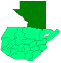
 Flores Location in Guatemala | |
| Coordinates: 16°55′47″N 89°53′30″W / 16.92972°N 89.89167°WCoordinates: 16°55′47″N 89°53′30″W / 16.92972°N 89.89167°W | |
| Country |
|
| Department |
|
| Government | |
| • Mayor | Armando Aragón (PP) |
| Population (2002) | |
| • Total | 13,700 |
| Climate | Aw |
Flores is the capital of the Petén Department, Guatemala's landlocked, northernmost department. The population is 13,700 (2003).
Flores is the seat of the municipality of Flores (population 22,600).
Its Catedral Nuestra Señora de Los Remedios y San Pablo Itzá is the cathedral episcopal see of the Apostolic Vicariate of El Petén (formerly a territorial prelature).

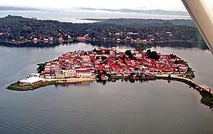
The old part of the city is located on an island on Lake Peten Itza, connected to the mainland by a short causeway. On the mainland is the suburb Santa Elena and, to the West, a contiguous municipality San Benito.
History
In Pre-Columbian times, Flores was the Maya city of Nojpetén.
Nojpetén
The Itza left the Yucatán region in the 13th century and built the city later known as Tayasal as their capital. They called it Nojpetén, (noj peten, literally "Great Island" in the Itza language).[1] The Spanish called it Tayasal, possibly derrived from ta Itza, or "Place of the Itza".[2]
It was here, on the island of Flores on the shore of Lake Petén Itzá, that the last independent Maya state held out against the Spanish conquerors. In 1541, Hernán Cortés came to the island, en route to Honduras, but needed to move on and did not try to conquer it.
The Spanish did not manage to conquer the island until 1697, when they marched in, attacked via boats, and destroyed it. Those who could flee did so, and many Itzá people hid in the jungle for years. From the ruins of Nojpetén arose the modern city of Flores. The modern city can thus be regarded as the second oldest continuously inhabited settlement in the Americas, after Cholula.
Transportation
Flores is served by Mundo Maya International Airport. Several international flights land here but most stop first at Guatemala City's La Aurora International Airport. The Island is also very well connected by bus, with many companies running overnight buses to Guatemala City
Gallery
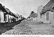
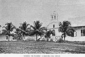
Flores in the 19th century
The first photographs ever made from Flores where those taken by engineer Claudio Urrutia in 1897, when he was in charge of the Guatemala-Mexico Border Commission.[3]

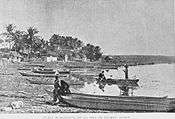
.jpg) Flores, as seen from San Benito
Flores, as seen from San Benito Engineering crew of the Guatemalan Border Commission. Claudio Urrutia, Commission Director is in the middle.
Flores in the 21st century
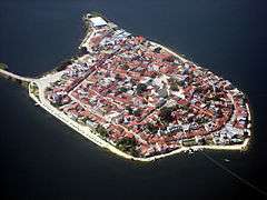 Aerial view of Flores Island from above Santa Elena.
 Sunset in Flores.
 Restaurant on Lake Peten Itza
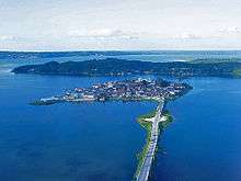 Causeway connecting the island .
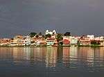
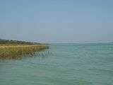 Shore of Lake Petén Itza.
 Classic period panel in the main plaza of Flores found in the nearby site of Ixlu.
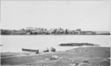 The island in 1917.
_-_Guatemala-1958.jpg) Aerial view of the City.
Aerial view of the City.
See also
| Wikimedia Commons has media related to Flores. |
References
- ↑ Reina 1966, p. 20.
- ↑ Rice 2009, p. 43.
- ↑ La Ilustración Guatemalteca & 1 April 1897, p. 246.
Bibliography
- La Ilustración Guatemalteca (1 April 1897). "Nuestros grabados: Límites con México". La Ilustración Guatemalteca (in Spanish). Guatemala: Síguere, Guirola & Cía. I (18).
- Reina, Ruben E. (Fall 1966). "A Peninsula That May Have Been an Island: Tayasal, Peten, Guatemala" (PDF). Expedition. Philadelphia, Pennsylvania, USA: University of Pennsylvania Museum of Archaeology and Anthropology. 9 (1). ISSN 0014-4738.
- Rice, Prudence M. (2009). "The Kowoj in Geopolitical-Ritual Perspective". In Prudence M. Rice and Don S. Rice (eds.). The Kowoj: identity, migration, and geopolitics in late postclassic Petén, Guatemala. Boulder, Colorado, US: University Press of Colorado. pp. 21–54. ISBN 978-0-87081-930-8. OCLC 225875268.
External links
| Wikivoyage has a travel guide for Flores (Guatemala). |