Flora, Oregon
| Flora, Oregon | |
|---|---|
| Unincorporated community | |
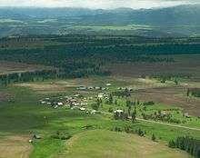 Flora, Oregon in 2008 | |
| Coordinates: 45°54′01″N 117°18′36″W / 45.90028°N 117.31000°WCoordinates: 45°54′01″N 117°18′36″W / 45.90028°N 117.31000°W[1] | |
| Country | United States |
| State | Oregon |
| County | Wallowa |
| Elevation[1] | 4,350 ft (1,330 m) |
Flora is an unincorporated community in Wallowa County, Oregon, United States. It is located about 35 miles north of Enterprise, just off Oregon Route 3, and is considered a ghost town. Its elevation is 4350 ft.[1]
History
Flora was platted on April 7, 1897.[2] By 1910, it had a population of 200 residents and an eight-room school. It is considered "the most substantial town to fail" in the Northeast Oregon region.[2]
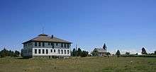
The community was named after the daughter of the first postmaster, A. D. Buzzard.[3] Flora post office operated from 1890–1966.[3] The Flora School, built in 1915, is on the National Register of Historic Places.[4] Now known as the Flora School Education Center, the schoolhouse has been restored as a pioneer arts education center.[5][6]
See also
References
- 1 2 3 "Flora". Geographic Names Information System. United States Geological Survey. November 28, 1980. Retrieved 2010-01-08.
- 1 2 Bailey, Barbara Ruth (1982). Main Street: Northeastern Oregon. Oregon Historical Society. pp. 55–58. ISBN 0-87595-073-6.
- 1 2 McArthur, Lewis A.; McArthur, Lewis L. (2003) [1928]. Oregon Geographic Names (7th ed.). Portland, Oregon: Oregon Historical Society Press. ISBN 978-0875952772.
- ↑ "Oregon National Register List" (PDF). Oregon Parks and Recreation Department. October 19, 2009. Retrieved 2010-01-08.
- ↑ [Heritage] Oregon Heritage News 2005-01-13
- ↑ Archived June 10, 2008, at the Wayback Machine.
External links
- Historic images of Flora from Salem Public Library
- Historic images of Flora from the University of Oregon Digital Archives
Municipalities and communities of Wallowa County, Oregon, United States | ||
|---|---|---|
| Cities | 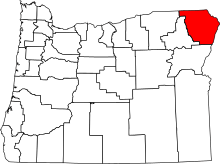 | |
| CDP | ||
| Other unincorporated communities | ||
| Ghost towns | ||