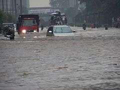
Flooding in Jakarta
Flooding in Jakarta occurs on the northwest coast of Java, at the mouth of the Ciliwung River on Jakarta Bay, which is an inlet of the Java Sea and has happened recently in 1996, 2002, 2007 and 2013.
Jakarta geography
- See also Jakarta#Geography
The area of the Jakarta Special District is 662 km2 of land area and 6,977 km2 of sea area.[1]
Jakarta lies in a low, flat basin, averaging 7 metres (23 ft) above sea level; 40% of Jakarta, particularly the northern areas, is below sea level,[2] while the southern parts are comparatively hilly.
Rivers flow from the Puncak highlands to the south of the city, across the city northwards towards the Java Sea; the Ciliwung River, divides the city into the western and eastern principalities. Other rivers include the Pesanggrahan, and Sunter high sea tides.
Other contributing factors include clogged sewage pipes and waterways that service an increasing population, in addition to deforestation near rapidly urbanizing Bogor and Depok in Jakarta's hinterland.
Jakarta is an urban area with complex socio-economic problems that indirectly contribute to triggering a flood event.[3]
1960 floods
In February 1960, flooding occurred in the new suburb of Grogol. Despite the flood-proof planning of Grogol suburb, the area was flooded to knee and waist height. This was the first crisis for Governor Soemarno who was installed only days before the floods began.[4]
1996 floods
Major floods occurred in 1996[5][6] when 5,000 hectares of land were flooded.[7]
2007 floods
- See also 2007 Jakarta flood
Major floods also occurred in 2007.[8] Losses from infrastructure damage and state revenue were at least 5.2 trillion rupiah (572 million US dollars) and at least 190,000 people have fallen ill due flood related illnesses. Approximately 70% of Jakarta's total area was flooded with water up to four meters deep in parts of the city.[9][10] 80 people were killed in the floods.
2013 floods
Pollution issues
In May 2011, the Jakarta Environmental Management Agency categorized all rivers in Jakarta as polluted; 71% of them were heavily polluted, 20% were partly polluted and 9% were lightly polluted.[11]
Remedies
Flood canals
East Flood Canal (Banjir Kanal Timur, BKT) in eastern Jakarta was a national project which began in 2003 and late 2009 reached the Java sea and will be accomplished in 2011. It was 23.5 kilometers length which linking five rivers: Cipinang, Sunter, Buaran, Jati Kramat and Cakung. It will reduce flood and hope as a 2 kilometers rowing sport venue too.[12] To ease from flood, Jakarta Emergency Dredging Innitiave (JEDI) phase-2 will make underground canal (siphon) from Ciliwung river to Cipinang river and then go through to East Flood Canal. It will lower floods at Cawang, Kampung Melayu, Bukit Duri and Kebun Baru. The length is one kilometer and is finished in 2016.[13]
Using participatory mapping for disaster preparedness in Jakarta
For managing risk effectively, it needs extensive data for making decisions on investments in preparedness, mitigation, and response. The detailed information on disaster situation (flooding) is hardly available at local level. OpenStreetMap is the online, open-source platform, which relies on participatory mapping conducted by local communities, private and public actors who collect the detailed information about a given area and share it, meet the needs in disaster situation. The pilot project in Jakarta was led by the Province of Jakarta's Disaster Management Agency collected high-resolution data to inform flood preparedness and contingency. Later, the data, which is accessible by the community and the general public, was used in 2011/2012 Jakarta contingency emergency planning exercise. The risk information it produces is very useful for decision makers in preparedness, development and investment planning.[14]
Continuing issues
Jakarta sinking
Besides flood from the rivers, Jakarta is also sinking about 5 to 10 centimeters each year and up to 20 centimeters in northern Jakarta mainland. From 2000 to 2050 the potential coastal flood extent is estimated to increase by 110.5 km2 due to both land subsidence and sea-level rise.[15] To solve it, the Netherlands will give $4 million for a feasibility study to build a dike on Jakarta Bay. The ring dike will be provided with pumping system and retention area, would regulate and control seawater and use also as additional toll road. The project will be built by 2025.[16]
Construction of an 8 km sea wall along the coast was officially launched on Oct. 9, 2014.[17]
See also
References
- ↑ Based on Governor Decree in 2007, No. 171. taken from Statistics DKI Jakarta Provincial Office, Jakarta in Figures, 2008, BPS, Province of DKI Jakarta
- ↑ "The Tides: Efforts Never End to Repel an Invading Sea". Jakarta Globe. Retrieved 15 November 2015.
- ↑ "Key to Jakarta's floods: Basin flood management". The Jakarta Post. 22 March 2008. Retrieved 14 March 2011.
- ↑ Merrillees 2015, p. 17.
- ↑ "Asian News". Asiaviews. Retrieved 27 April 2010.
- ↑ "Floods in DKI Jakarta Province, updated 19 February 2007 Emergency Situation Report No. 6". ReliefWeb. 19 February 2007.
- ↑ "1996 Global Register of Major Flood Events". Dartmouth Flood Observatory. Dartmouth College.
- ↑ "Asia". Bloomberg. 4 February 2007. Retrieved 27 April 2010.
- ↑ Jakarta Flood Feb 2007 « (Geo) Information for All
- ↑ 2007 Global Register of Major Flood Events, Dartmouth Flood Observatory, 1 May 2008
- ↑ Jakartans lament the sorry state of the capital’s rivers. The Jakarta Post, Jakarta. May 20, 2011
- ↑ Minister: Jakarta East Flood Canal accomplished in 2011. Waspada.co.id (30 November 2010). Retrieved 12 June 2011.
- ↑ :: Wartakotalive.com | Berita : Kali Ciliwung Disodet. Wartakota.co.id (14 April 2010). Retrieved 12 June 2011.
- ↑ (PDF) https://www.gfdrr.org/sites/gfdrr/files/publication/Pillar_1_Using_Participatory_Mapping_for_Disaster_Preparedness_in_Jakarta_OSM.pdf. Missing or empty
|title=(help) - ↑ "Projection of coastal floods in 2050 Jakarta". Urban Climate. Elsevier. 17: 135–145. 2016-09-27. doi:10.1016/j.uclim.2016.05.003. Retrieved 2016-11-07.
- ↑ "Dutch to study new dike for Jakarta Bay". The Jakarta Post. 2011-07-27. Retrieved 2014-01-20.
- ↑ Kusuma, Adriana Nina (9 October 2014). "Indonesia Holds Groundbreaking Ceremony for Giant Sea Wall". The Jakarta Globe. Retrieved 10 October 2014.
Cited works
- Merrillees, Scott (2015). Jakarta: Portraits of a Capital 1950-1980. Jakarta: Equinox Publishing. ISBN 9786028397308.