Flaxton, North Yorkshire
| Flaxton | |
|---|---|
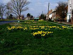 Rice Lane, Flaxton | |
 Flaxton Flaxton shown within North Yorkshire | |
| Population | 343 (2011) |
| OS grid reference | SE678623 |
| Civil parish |
|
| District | |
| Shire county | |
| Region | |
| Country | England |
| Sovereign state | United Kingdom |
| Post town | YORK |
| Postcode district | YO60 |
| Police | North Yorkshire |
| Fire | North Yorkshire |
| Ambulance | Yorkshire |
| EU Parliament | Yorkshire and the Humber |
| UK Parliament |
|
Flaxton is a small village and civil parish in the Ryedale district of North Yorkshire, England. It is close to the A64 between York and Malton. The village lies entirely within a Conservation Area as defined by Planning (Listed Building and Conservation Areas Act) 1990.[1]
History
The village is mentioned in the Domesday Book as Flaxtune in the Bulford hundred. At that time it was part of the manor of Foston and was in the possession of Earl Morcar, but passed to Count Alan of Brittany by 1086.[2] The etymology of the name is taken from Old English meaning settlement where flax is made.[3]
Flaxton was served by Flaxton railway station on the York to Scarborough Line between 1845 and 1930.[4]
The village had a local Church of England school built in 1867, but it closed in 1987. Though no longer in use it is a Grade II Listed Building.[5][6]
Governance
The village lies within the Thirsk and Malton (UK Parliament constituency). It is also within the Hovingham & Sheriff Hutton electoral division of North Yorkshire County Council and the Sheriff Hutton ward of Ryedale District Council.[7]
Geography
The nearest settlements to the village are Claxton, North Yorkshire 1.5 miles (2.4 km) to the south; West Lilling 2.2 miles (3.5 km) to the north-west; Harton, North Yorkshire 1.5 miles (2.4 km) to the east and Thornton-le-Clay 1.6 miles (2.6 km) to the north-east.[7]
The 1881 UK Census recorded the population as 366.[5] According to the 2001 UK Census, the village had a population of 331, of which 255 were over the age of sixteen. Of these, 168 were in employment. There were 138 dwellings, of which 86 were detached. [8] The 2011 Census showed a population of 343.[9]
The village areas around Flaxton Village Green and the Crofts are designated Sites of Importance for Nature Conservation (SINCs). Here can be found semi-improved and unimproved neutral grassland, as well as wet grassland on the Keld with three ponds that include two great crested newt breeding sites.[3]
It has one pub, the Thompson Arms Inn, and a B&B, the Blacksmiths Arms.
Religion
The village has a church dedicated to St Lawrence, which was built in 1853.[5]
.jpg) St Lawrence's Church
St Lawrence's Church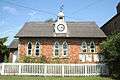 Parish council meeting rooms in Flaxton, formerly the school
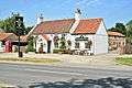 Flaxton, Blacksmiths Arms
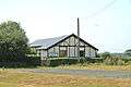 Flaxton Village Hall
References
- ↑ "Conservation Area". Archived from the original on 22 September 2013. Retrieved 22 December 2012.
- ↑ Flaxton in the Domesday Book. Retrieved 22 December 2012.
- 1 2 "Etymology" (PDF). Archived from the original (PDF) on 19 November 2012. Retrieved 22 December 2012.
- ↑ Butt, R. V. J. (1995). The Directory of Railway Stations: details every public and private passenger station, halt, platform and stopping place, past and present (1st ed.). Sparkford: Patrick Stephens Ltd. ISBN 978-1-85260-508-7. OCLC 60251199.
- 1 2 3 Bulmer's Topography, History and Directory (Private and Commercial) of North Yorkshire 1890. S&N Publishing. 1890. p. 705. ISBN 1-86150-299-0.
- ↑ "Old School". Retrieved 22 December 2012.
- 1 2 "OpenData Viewer". Ordnance Survey. Archived from the original on 5 October 2012. Retrieved 14 October 2012.
- ↑ "2001 UK Census". Neighbourhood Statistics. Office for National Statistics. Retrieved 22 December 2012.
- ↑ UK Census (2011). "Local Area Report – Flaxton Parish (1170217237)". Nomis. Office for National Statistics. Retrieved 17 March 2018.
External links
![]()