Flatfork, West Virginia
| Flatfork | |
|---|---|
| Unincorporated community | |
 Flatfork Location within the state of West Virginia | |
| Coordinates: 38°42′27″N 81°29′47″W / 38.70750°N 81.49639°WCoordinates: 38°42′27″N 81°29′47″W / 38.70750°N 81.49639°W | |
| Country | United States |
| State | West Virginia |
| County | Roane |
| Elevation | 778 ft (237 m) |
| Time zone | UTC-5 (Eastern (EST)) |
| • Summer (DST) | UTC-4 (EDT) |
| GNIS feature ID | 1740882[1] |
Flatfork is an unincorporated community in Roane County, in the U.S. state of West Virginia.[2]
History
A post office called Flat Fork was established in 1857, the name was changed to Flatfork in 1895, and the post office closed in 1935.[3] The community takes its name from nearby Flat Fork creek.[4]
References
- ↑ U.S. Geological Survey Geographic Names Information System: Flatfork, West Virginia
- ↑ U.S. Geological Survey Geographic Names Information System: Flatfork, West Virginia
- ↑ "Post Offices". Jim Forte Postal History. Archived from the original on 6 March 2016. Retrieved 28 April 2015.
- ↑ Kenny, Hamill (1945). West Virginia Place Names: Their Origin and Meaning, Including the Nomenclature of the Streams and Mountains. Piedmont, WV: The Place Name Press. p. 243.
Municipalities and communities of Roane County, West Virginia, United States | ||
|---|---|---|
| City | 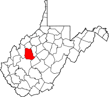 | |
| Town | ||
| Unincorporated communities |
| |
| Ghost towns | ||
| Footnotes | ‡This populated place also has portions in an adjacent county or counties | |
This article is issued from
Wikipedia.
The text is licensed under Creative Commons - Attribution - Sharealike.
Additional terms may apply for the media files.