Flüela Wisshorn
| Flüela Wisshorn | |
|---|---|
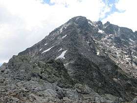 North side | |
| Highest point | |
| Elevation | 3,085 m (10,121 ft) |
| Prominence | 632 m (2,073 ft) [1] |
| Isolation | 3.42 kilometres (2.13 mi) |
| Parent peak | Piz Linard |
| Coordinates | 46°45′43.65″N 9°57′59.813″E / 46.7621250°N 9.96661472°ECoordinates: 46°45′43.65″N 9°57′59.813″E / 46.7621250°N 9.96661472°E |
| Geography | |
 Flüela Wisshorn Location in Switzerland | |
| Location | Graubünden, Switzerland |
| Parent range | Silvretta Alps |
| Climbing | |
| First ascent | 1880 by O. Schuster, A. Rzewuski, and B. Tauscher [2] |
The Flüela Wisshorn is a mountain of the Silvretta Alps, overlooking the Flüela Pass in the Swiss canton of Graubünden.
Access roads
The climbing route starts from the road which leads to the Fluela pass (2383 m). You can get there by following an attractive road from Davos in the north-west or from Susch in the east.
The normal route to the summit
You can start walking directly from the pass or from the parking at 2207 m above the sea level below the pass in the direction of Davos. This is a simple walk in the north-east direction towards the Winterlucke pass which is at 2787 m. From there the summit is clearly visible, just follow the rocky ridge.
References
- ↑ Swisstopo maps
- ↑ Günther Flaig, Silvretta alpin: ein Führer für Täler, Hütten und Gipfel, Bergverlag Rother GmbH, 2005, p. 298
External links
- Flüela Wisshorn on Hikr
- Flüela Wisshorn on Mountains for Everybody.
This article is issued from
Wikipedia.
The text is licensed under Creative Commons - Attribution - Sharealike.
Additional terms may apply for the media files.