Flörsbach (Lohr)
| Flörsbach | |
|---|---|
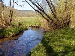 Confluence of Flörsbach and Lohrbach | |
| Country | Germany |
| States | Hesse |
| Physical characteristics | |
| Main source |
near Flörsbach, an Ortsteil of Flörsbachtal c. 400 m (1,300 ft) above sealevel |
| River mouth |
Joins Lohrbach to form the Lohr near Kempfenbrunn 270 m (890 ft) above sealevel 50°06′02″N 9°27′36″E / 50.1006°N 9.4600°ECoordinates: 50°06′02″N 9°27′36″E / 50.1006°N 9.4600°E |
| Length | 5.9 km (3.7 mi) |
| Basin features | |
| Progression | Lohr→ Main→ Rhine→ North Sea |
| Basin size | c. 15 km2 (5.8 sq mi) |
Flörsbach is a river in the municipality of Flörsbachtal in the Main-Kinzig district of Hesse, Germany.[1]
Course
The Flörsbach rises near the village of the same name from several springs and then mostly flows southeast, parallel to the Bundesstrasse 276, through Kempfenbrunn and then joins with the Lohrbach to form the Lohr.[1]
See also
References
| Wikimedia Commons has media related to Flörsbach. |
- 1 2 Google (11 February 2018). "Flörsbach (Lohr)" (Map). Google Maps. Google. Retrieved 11 February 2018.
This article is issued from
Wikipedia.
The text is licensed under Creative Commons - Attribution - Sharealike.
Additional terms may apply for the media files.