Fjaðrárgljúfur
Coordinates: 63°46′16.5″N 18°10′19″W / 63.771250°N 18.17194°W

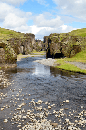
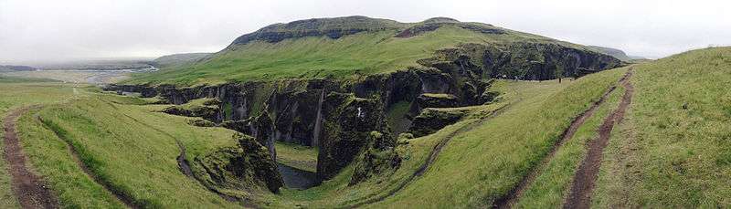
Fjaðrárgljúfur (pronounced [ˈfjaːðraurˌkljuːvʏr̥]) is a canyon in south east Iceland which is up to 100 m (330 ft) deep[1] and about 2 kilometres (1.2 miles) long, with the Fjaðrá river flowing through it.[2] The canyon has steep walls and winding water. Its origins dates back to the cold periods of the Ice Age, about two million years ago. It is located near the Ring Road, not far from the village of Kirkjubæjarklaustur.[3] The canyon was created by progressive erosion by flowing water from glaciers through the rocks and palagonite over millennia.[4] A waterfall flows down the western side of the canyon, visible from an observation platform at the end of a one-mile hike up the eastern edge.[5]
See also
References
- ↑ "EnjoyIceland.is - Fjaðrárgljúfur - A canyon - South East Iceland". enjoyiceland.is. Retrieved 19 Sep 2012.
- ↑ Collectif; Dominique Auzias; Jean-Paul Labourdette (27 April 2011). Islande. Petit Futé. pp. 188–. ISBN 978-2-7469-4837-2. Retrieved 19 September 2012.
- ↑ Jane Victoria Appleton; Lisa Gail Shannen (16 December 2010). Frommer's Iceland. John Wiley & Sons. pp. 274–. ISBN 978-1-119-99443-5. Retrieved 19 September 2012.
- ↑ Íslandshandbókin. 2. bindi. 1989, S.695
- ↑ "Iceland In 8 Days: Deep Inside Fjadrargljufur Canyon". icelandin8days.com. Retrieved 22 Jan 2018.
External links
| Wikimedia Commons has media related to Fjaðrárgljúfur. |