Primorsk, Kaliningrad Oblast
| Primorsk Приморск (Russian) | |
|---|---|
| - Town[1] - | |
.svg.png) Location of Kaliningrad Oblast in Russia | |
 Primorsk | |
 | |
|
Coat of arms | |
| Administrative status (as of November 2011) | |
| Country | Russia |
| Federal subject | Kaliningrad Oblast[1] |
| Administrative district | Baltiysky District[1] |
| Town of district significance | Primorsk[1] |
| Administrative center of | town of district significance of Primorsk[1] |
| Municipal status (as of July 2009) | |
| Municipal district | Baltiysky Municipal District[2] |
| Urban settlement | Primorskoye Urban Settlement[2] |
| Administrative center of | Primorskoye Urban Settlement[2] |
| Statistics | |
| Population (2010 Census) | 1,956 inhabitants[3] |
| Time zone | USZ1 (UTC+02:00)[4] |
| Founded | 1268[5] |
| Town status since | 2008 |
| Previous names |
Fischhausen (until 1945),[5] Fishkhauzen (until 1946)[5] |
| Postal code(s)[6] | 238510 |
| Primorsk on Wikimedia Commons | |
Primorsk (Russian: Примо́рск), prior to 1946 known by its German name Fischhausen (Lithuanian: Žuvininkai/Skanavikas; Polish: Rybaki), is a town in Baltiysky District of Kaliningrad Oblast, Russia, located on the Vistula Lagoon.
Its population is 1,956 (2010 Census);[3] compared to 2,150 (2002 Census);[7] 1,792 (1989 Census).[8].
Geography
The town is located in the southwest of the Sambia Peninsula (Samland). It is situated by a bay on the northern shore of the Vistula Lagoon, about 30 km (19 mi) west of the administrative centre Kaliningrad.
History
The site has been associated with the name of St. Adalbert of Prague, who was send with soldiers of Boleslav Chrobry of newly established Poland to conquer Prussia. St. Adalbert was beheaded nearby in 997 by the pagan Sambians after he destroyed their sacred oak grove. Several further attempts of conquest by Poles followed, but were successfully repelled. In 1254 the Old Prussian Samland territory was conquered by forces of the Teutonic Order, led by King Ottokar II of Bohemia, during the Prussian Crusade.
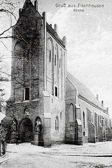
.JPG)
Upon the division of the conquered lands, the Bishop of Samland had a castle erected at the site named Schonewik (derived from Old Prussian: Skanevīs). First mentioned in a 1268 deed,[5] it is one of the oldest in the region. A settlement was laid out from 1299 onwards and its citizens, mainly descending from Stralsund in the Danish Principality of Rügen, received a first town charter in 1305. As the episcopal residence of the Samland bishops, it was called Bischoveshusen or shortly Vischhusen from about 1325. The richly endowed Gothic parish church was one of the oldest in the province.
When in 1525 Bishop George of Polentz waived his rights, his Fischhausen residence was incorporated into the secular Duchy of Prussia. On 12 February 1526, the Hohenzollern duke Albert, former Grand Master of the Teutonic Knights, married Princess Dorothea of Denmark at the Fischhausen Castle chapel. The fortress became the residence of his mentally disabled son Albert Frederick until his death in 1618. Afterwards, the castle decayed and was finally demolished by order of King Frederick I of Prussia, who had its stones used for the expansion of the nearby Pillau fortress.
Upon the re-organisation of the Prussian lands after the Congress of Vienna, Fischhausen became the administrative seat of a district (Kreis Fischhausen) within the Province of East Prussia in 1818. A station on the East Prussian Southern Railway line from Königsberg to Pillau with a branch-off to Palmnicken (Yantarny) on the Amber Coast was inaugurated in 1865. According to the German 1939 census, the town's population was 3,879.
During World War II, the Soviet Red Army advanced towards Fischhausen after the capture of Königsberg. The town was captured after a battle on April 21–24, 1945; during the fighting the medieval town was almost completely destroyed. After the war, the town was transferred to Soviet control and in 1946 it was given its present name (which literally means "maritime" in Russian). It finally lost its status as a district seat and was incorporated into Zelenogradsky District in 1947. Part of the newly established Baltiysky District since 1996, it was demoted in status to that of an urban-type settlement in 2005. In 2008, its town status was restored.
Administrative and municipal status
Within the framework of administrative divisions, it is incorporated within Baltiysky District as the town of district significance of Primorsk.[1] As a municipal division, the town of district significance of Primorsk is incorporated within Baltiysky Municipal District as Primorskoye Urban Settlement.[2]
Notable people
- Arthur von Hippel (1841–1916), ophthalmologist
- Wilhelm Wien (1864–1928), physicist
- Dietrich von Saucken (1892–1980), general
- Marie Jonas (1893–1944), physician
- Arno Motulsky (1923–2018), physician and geneticist
References
Notes
- 1 2 3 4 5 6 Resolution #640
- 1 2 3 4 Law #274
- 1 2 Russian Federal State Statistics Service (2011). "Всероссийская перепись населения 2010 года. Том 1" [2010 All-Russian Population Census, vol. 1]. Всероссийская перепись населения 2010 года (2010 All-Russia Population Census) (in Russian). Federal State Statistics Service. Retrieved June 29, 2012.
- ↑ Правительство Российской Федерации. Федеральный закон №107-ФЗ от 3 июня 2011 г. «Об исчислении времени», в ред. Федерального закона №271-ФЗ от 03 июля 2016 г. «О внесении изменений в Федеральный закон "Об исчислении времени"». Вступил в силу по истечении шестидесяти дней после дня официального опубликования (6 августа 2011 г.). Опубликован: "Российская газета", №120, 6 июня 2011 г. (Government of the Russian Federation. Federal Law #107-FZ of June 31, 2011 On Calculating Time, as amended by the Federal Law #271-FZ of July 03, 2016 On Amending Federal Law "On Calculating Time". Effective as of after sixty days following the day of the official publication.).
- 1 2 3 4 Энциклопедия Города России. Moscow: Большая Российская Энциклопедия. 2003. p. 361. ISBN 5-7107-7399-9.
- ↑ Почта России. Информационно-вычислительный центр ОАСУ РПО. (Russian Post). Поиск объектов почтовой связи (Postal Objects Search) (in Russian)
- ↑ Russian Federal State Statistics Service (May 21, 2004). "Численность населения России, субъектов Российской Федерации в составе федеральных округов, районов, городских поселений, сельских населённых пунктов – районных центров и сельских населённых пунктов с населением 3 тысячи и более человек" [Population of Russia, Its Federal Districts, Federal Subjects, Districts, Urban Localities, Rural Localities—Administrative Centers, and Rural Localities with Population of Over 3,000] (XLS). Всероссийская перепись населения 2002 года [All-Russia Population Census of 2002] (in Russian). Retrieved August 9, 2014.
- ↑ Demoscope Weekly (1989). "Всесоюзная перепись населения 1989 г. Численность наличного населения союзных и автономных республик, автономных областей и округов, краёв, областей, районов, городских поселений и сёл-райцентров" [All Union Population Census of 1989: Present Population of Union and Autonomous Republics, Autonomous Oblasts and Okrugs, Krais, Oblasts, Districts, Urban Settlements, and Villages Serving as District Administrative Centers]. Всесоюзная перепись населения 1989 года [All-Union Population Census of 1989] (in Russian). Институт демографии Национального исследовательского университета: Высшая школа экономики [Institute of Demography at the National Research University: Higher School of Economics]. Retrieved August 9, 2014.
Sources
- Правительство Калининградской области. Постановление №640 от 30 августа 2011 г. «Об утверждении реестра объектов административно-территориального деления Калининградской области», в ред. Постановления №877 от 21 ноября 2011 г «О внесении изменения в Постановление Правительства Калининградской области от 30 августа 2011 г. №640». Вступил в силу со дня официального опубликования. Опубликован: "Калининградская правда" (вкладыш "Официально"), №170, 15 сентября 2011 г. (Government of Kaliningrad Oblast. Resolution #640 of August 30, 2011 On the Adoption of the Registry of the Objects of the Administrative-Territorial Divisions of Kaliningrad Oblast, as amended by the Resolution #877 of November 21, 2011 On Amending the Resolution of the Government of Kaliningrad Oblast #640 of August 30, 2011. Effective as of the day of the official publication.).
- Калининградская областная Дума. Закон №274 от 3 июля 2008 г «Об организации местного самоуправления на территории муниципального образования "Балтийский городской округ"», в ред. Закона №370 от 1 июля 2009 г «О составе территорий муниципальных образований Калининградской области». Вступил в силу со дня официального опубликования. Опубликован: "Калининградская правда", №124, 11 июля 2008 г. (Kaliningrad Oblast Duma. Law #274 of July 3, 2008 On the Organization of the Local Self-Government on the Territory of the Municipal Formation of "Baltiysky Urban Okrug", as amended by the Law #370 of July 1, 2009 On the Composition of the Territories of the Municipal Formations of Kaliningrad Oblast. Effective as of the day of the official publication.).
| Districts | ||
|---|---|---|
| Cities and towns | ||
| Urban-type settlements of oblast significance | ||
| Urban-type settlements | ||