Fernbridge, California
| Fernbridge, California | |
|---|---|
| Unincorporated community | |
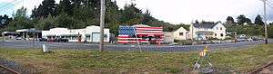 View of Fernbridge along 211 | |
| Country | United States |
| State | California |
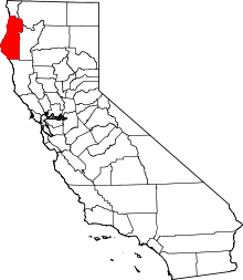
| County | Humboldt County |
| Elevation[1] | 39 ft (12 m) |
Fernbridge is an unincorporated community at an elevation of 39 feet (12 m) in Humboldt County, California,[1] named for a historic bridge, 3 miles (4.8 km) west-northwest of Fortuna.[2]
Town of Fernbridge
The unincorporated area named Fernbridge lies between the Eel River and Highway 101 bisected by unused Northwestern Pacific Railroad tracks. The Humboldt Creamery, a roadhouse, the old railway depot, several warehouses, a fuel depot and several houses line Fernbridge Drive (Old U.S. 101)[3] which now serves as an access road between exits 691 and 692.
Fernbridge is a stop on the Humboldt Transit Authority fixed route transit bus systems, served by the Redwood Transit System connecting north and south Humboldt along 101. Fernbridge ZIP Code is 95540 and the community is inside area code 707.
The United States Geological Survey maintains a webcam overlooking Fernbridge,[4] and a river gage[5] of water level at the bridge.
Early history
The area was first named Singley Station in 1885 after George Singley who ran a ferry across the Eel River from 1876 to 1880. As soon as the station was built, a stage ran on a regular schedule to connect to the train. By 1891, the ferry was pulled by a steam winch and a seasonal pontoon bridge was added in the summer.[6]
The town name was changed to Fernbridge from Singley's Station about two years after the Fernbridge was built across the Eel in 1910-1911. The first post office at Fernbridge opened in 1924.[2]
In 1934, when California numbered and marked California State Route 1, the route began in Las Cruces, California and ended at Fernbridge,[7] although by 1984, admitting the route was not feasible south of Ferndale, this section of Route 1 was renumbered to State Highway 211.[8]
See also
References
| Wikimedia Commons has media related to Fernbridge, California. |
- 1 2 U.S. Geological Survey Geographic Names Information System: Fernbridge, California
- 1 2 Durham, David L. (1998). California's Geographic Names: A Gazetteer of Historic and Modern Names of the State. Clovis, Calif.: Word Dancer Press. p. 59. ISBN 1-884995-14-4.
- ↑ "California 211". Retrieved 2 June 2011.
- ↑ "Fernbridge Web Cam on Eel River". United States Geological Survey (USGS). Retrieved 2 June 2011.
- ↑ USGS & DWR. "Current Sensor Data for Fernbridge (Eel River - CDEC Station FER)". California Data Exchange Center (CDEC). Archived from the original on 2009-08-10.
- ↑ The Ferndale Museum (2004). Bess Carol; Beryl Newman; Ann Roberts, eds. Images of America: Ferndale. Charleston, South Carolina: Arcadia Publishing. p. 128. 0-7385-2890-0.
- ↑ California Highways and Public Works (August 1934). "State Routes will be Numbered and Marked with Distinctive Bear Signs". GBCnet. Retrieved 3 June 2011.
- ↑ California State Assembly. "An act...relating to state highways". 1983–1984 Session of the Legislature. Statutes of California. State of California. Ch. 409 p. 1769, 1774.