Fehmarn Belt
| Fehmarn Belt | |
|---|---|
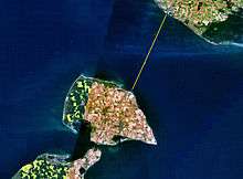
 The Fehmarn Belt. The German island of Fehmarn is located to the south and the Danish island of Lolland to the north | |
| Type | strait |
| Basin countries |
|
| Max. length | 25 km (16 mi) |
| Min. width | 18.6 km (11.6 mi) |
| Max. depth | 30 m (98 ft) |
Fehmarn Belt (![]()
The strait features an 18-kilometre (10 nmi) wide area with depths of 20–30 metres. Currents in the strait are weak and mostly dependent on wind.
Swimming
It was initially swum across by Christof Wandratsch[1].
Tunnel proposal
The Danish and German governments agreed on 29 June 2007 to build a fixed link to replace the ferry route. It is to save an hour on crossing the strait, and provide more crossing capacity.
In 2011, the Danish parliament voted overwhelmingly (with seven of eight parties supporting) for the €5.1 billion project that is intended to open in 2020.[2] The tunnel is to have three separate bores, two containing two motorway lanes each, and one with a double-track railway line.[2]
Famous shipwrecks
- 21 July 1932 School ship Niobe
See also
| Wikimedia Commons has media related to Fehmarn Belt. |
References
- ↑
- 1 2 "Dänemark baut Supertunnel nach Deutschland". Der Spiegel, online edition (in German). 1 February 2011. Retrieved 1 February 2011.