Fayence-Tourrettes Airfield
| Fayence-Tourrettes Airfield Aérodrome Fayence - Tourrettes | |||||||||||||||||||
|---|---|---|---|---|---|---|---|---|---|---|---|---|---|---|---|---|---|---|---|
| Summary | |||||||||||||||||||
| Airport type | Public | ||||||||||||||||||
| Owner/Operator | Association Aéronatique Provence Côte d'Azur (AAPCA) | ||||||||||||||||||
| Location | Fayence / Tourrettes, France | ||||||||||||||||||
| Elevation AMSL | 738 ft / 225 m | ||||||||||||||||||
| Coordinates | 43°36′29″N 006°42′06″E / 43.60806°N 6.70167°E | ||||||||||||||||||
| Website | www.aapca.net | ||||||||||||||||||
| Runways | |||||||||||||||||||
| |||||||||||||||||||
|
Source: French AIP[1] | |||||||||||||||||||
Fayence-Tourrettes Airfield (French: Aérodrome Fayence - Tourrettes) (ICAO: LFMF) is a small airfield located 1.5 kilometres (1 mi) south of Fayence[1] and Tourrettes, both communes of the Var department in the Provence-Alpes-Côte d'Azur region of southeastern France.
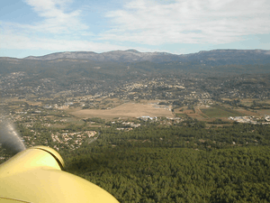
It is home to a large gliding club, the Association Aéronatique Provence Côte d'Azur (AAPCA) and to one microlight school. Runway 10L has two small tarmac landing strips for the exclusive use of gliders.
References
- 1 2 LFMF – FAYENCE. AIP from French Service d'information aéronautique, effective 11 October 2018.
External links
This article is issued from
Wikipedia.
The text is licensed under Creative Commons - Attribution - Sharealike.
Additional terms may apply for the media files.