Farndale
| Farndale | |
|---|---|
 Farndale | |
 Farndale Farndale shown within North Yorkshire | |
| Population | 207 (2011)[1] |
| OS grid reference | SE673952 |
| Civil parish |
|
| District | |
| Shire county | |
| Region | |
| Country | England |
| Sovereign state | United Kingdom |
| Post town | YORK |
| Postcode district | YO62 7 |
| Dialling code | 01751 |
| Police | North Yorkshire |
| Fire | North Yorkshire |
| Ambulance | Yorkshire |
| EU Parliament | Yorkshire and the Humber |
| UK Parliament |
|
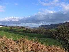
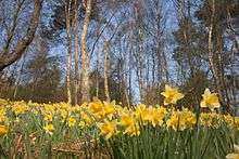
The valley of Farndale lies at the heart of the North York Moors. Each spring, its glorious daffodils put on one of nature's most spectacular shows – a dazzling display of colour that carpets the meadows and river banks along a seven-mile stretch of the River Dove[2]. The valley located in the North York Moors National Park in North Yorkshire, England. The nearest town is Kirkbymoorside located some 11 miles to the south. Pickering is some 17 miles to the south-east and Helmsley 17 miles to the south-west.
The population of the civil parishes of Farndale was 207 (Please note: Farndale East & Farndale West are both reported with combined figures) in 2011.
Farndale is an isolated, scattered agricultural community with traditional Yorkshire dry stone walls. The valley is popular with walkers due to its famous wild daffodils, which can be seen around Easter time all along the banks of the River Dove. To protect the daffodils the majority of Farndale north of Lowna was created a Local Nature Reserve in 1955.
Farndale is home to 3 hamlets – Church Houses and High Mill at the top of the valley and Low Mill further down. Low Mill is a tourist honeypot during daffodil season as this is where the famous daffodil walk begins.
The annual Farndale Agricultural Show[3] which is held on the Summer Bank Holiday Monday in Late August is a popular local event. The 100th Show was held in 2006.[4]
Etymology
Sources disagree on the origin of the name Farndale, although it is a combination of two parts "Farn" and "Dale".
There a four possible origins for "Farn" all of which do describe the dale. It may be derived from the Celtic "Faren" meaning beautiful [5] alternatively it could derived from the Scandinavian "FæN" meaning sheep [6] or possibly from Old English "Fearn" meaning fern or ferny place [7] or from the Gaelic "Feàrna" which means alder tree of which there are many in Farndale [8].
While Dale probably means Valley either derived from Scandinavion "Dalr" [9] or Anglian "Dæl" [10] although it could be derived from the Gaelic "Dail" meaning level field by a river [11].
The name of the River Dove which Flows though Farndale is almost definitely from either the Old British "Dubo" [12] meaning Black or from the Gaelic "Dubh" [13] also meaning black hence Black (or Dark) River.
Geography
Farndale is a valley within the North York Moors, it is surrounded by some of the wildest moorland in England. The dale is sandwiched between Bransdale to the west, Rosedale to the east and Westerdale to the north. To the north-east sits Blakey Ridge at over 400 m above sea level, and to the north-west, Cockayne Ridge reaching up to 454 m above sea level is one of the highest points of the North York Moors. The southern boundary of Farndale is technically Harland Beck and Shortsha Beck (across Lowna Lund)[14]although the Gillamoor to Hutton-le-Hole road is often taken as the boundary, south of this the dale continues but changes its name to Douthwaitedale, though the Tabular Hills until is reaches Keldhome then Kirkby Mills just east of Kirkbymoorside.
The River Dove rises on Wetsredale Moor North of Farndale, then flows through Farndale south-east past to Church Houses. Here it turns south and continues meandering past Low Mill to Lowna. At Gillamoor it heads south-east again past Hutton-le-Hole before returning southwards past Ravenswick and to the east of Kirkbymoorside. It continues past Keldholme and Kikrby Mills to Great Edstone. From there it flows south south-east to where it joins the River Rye in the Vale of Pickering near the village of Salton. Several tributaries meet the Dove through Farndale two of these make the valley is almost 'cactus' shaped, with a long central valley following the River Dove, and two side branches to make the arms - Blakey Gill near Church Houses and West Gill near Low Mill [15].
Local Nature Reserve
The Farndale Local Nature Reserve constitutes the majority of Farndale, which is a dale within the North York Moors National Park. It was created in 1955 to protect the wild daffodils (narcissus pseudonarcissus), for which the dale is famed. The Local Nature reserve comprises the larger part of the Farndale Site of Special Scientific Interest which comprises 157.3 Ha / 388.8 ac.[16]
Long Distance FootPaths
Around the north of Farndale, between Bloworth Crossing and Blakey is the track bed of the old Rosedale Ironstone Railway (Rosedale Branch) which forms part of two Long Distance Footpaths these being Wainwright's Coast to Coast Walk and The Lyke Wake Walk.
Governance
In the past Farndale was split into two Civil Parishes along the course of the River Dove with Farndale East Parish Council responsible for the eastern side including Church Houses and Farndale West Parish Meeting looking after the western side including Low Mill. Since April 2018 a joint Farndale Parish Council was formalised under a grouping order and now represents the interests of all residents in Farndale.
The 2nd tier of Local Government is Ryedale District Council and the third tier North Yorkshire County Council, historically being part of the North Riding of Yorkshire.
Farndale is part of the Thirsk and Malton UK Parliament constituency and the Yorkshire and Humber European Parliamentary constituency.
See also
References
- ↑ UK Census (2011). "Local Area Report – Farndale West Parish (1170217236)". Nomis. Office for National Statistics. Retrieved 22 August 2018.
- ↑ "Farndale". North York Moors.
- ↑ "farndale Show". Farndale Show.
- ↑ "Centenary show is the biggest and best yet". Gazette & Herald. 31 August 2006. Retrieved 12 December 2012.
- ↑ "Faren". Urban dictionary.
- ↑ "Glossary of Scandinavian origins of place names in Britain". Ordnace Survey.
- ↑ "Key to English Place Names". Nottingham University.
- ↑ "Glossary of Gaelic origins of place names in Britain". Ordnace Survey.
- ↑ "Glossary of Scandinavian origins of place names in Britain". Ordnace Survey.
- ↑ "Key to English Place Names". Nottingham University.
- ↑ "Glossary of Gaelic origins of place names in Britain". Ordnace Survey.
- ↑ "Cetic Place Names". Yorkshire Dialect.
- ↑ "Glossary of Gaelic origins of place names in Britain". Ordnace Survey.
- ↑ Ordnance Survey. Explorer OL26 Map. Ordance Surver. pp. South Sheet. ISBN 0-319-23461-4.
- ↑ "Farndale". Moors Knowledge.
- ↑ "Farndale SSSI" (PDF). Archived from the original (PDF) on 4 March 2016. Retrieved 13 June 2016.
External links
- Farndale community website
- BBC Look North (11 April 2007). "Yorkshire A-Z: Farndale" (video). BBC News. Retrieved 4 January 2010.
- Farndale Show Website
- Farndale Parish Council