Fara, Bloke
| Fara | |
|---|---|
| Village | |
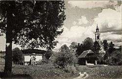 1963 postcard of Fara | |
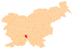
 Fara Location in Slovenia | |
| Coordinates: 45°46′0.47″N 14°30′28.64″E / 45.7667972°N 14.5079556°ECoordinates: 45°46′0.47″N 14°30′28.64″E / 45.7667972°N 14.5079556°E | |
| Country |
|
| Traditional region | Inner Carniola |
| Statistical region | Littoral–Inner Carniola |
| Municipality | Bloke |
| Area | |
| • Total | 13.09 km2 (5.05 sq mi) |
| Elevation | 717.1 m (2,352.7 ft) |
| Population (2002) | |
| • Total | 56 |
| [1] | |
Fara (pronounced [ˈfaːɾa]) is a settlement just south of Nova Vas in the Municipality of Bloke in the Inner Carniola region of Slovenia.[2]
Name
The settlement was formerly called Male Bloke (literally, 'little Bloke'), distinguishing it from Velike Bloke (literally, 'big Bloke'). The Bloke parish church was built in the settlement and the name Fara (literally, 'parish') became the name of the settlement.[2]
Church
The parish church in the village is dedicated to Saint Michael and belongs to the Roman Catholic Archdiocese of Ljubljana. It has been an independent parish since at least the 14th century.[3]
References
External links
| Wikimedia Commons has media related to Fara, Bloke. |
| Settlements | Administrative centre: Nova Vas
|  |
|---|---|---|
| Landmarks |
| |
This article is issued from
Wikipedia.
The text is licensed under Creative Commons - Attribution - Sharealike.
Additional terms may apply for the media files.