Falknis
| Falknis | |
|---|---|
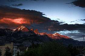 Falknis at sunset, photographed from Sargans in Switzerland | |
| Highest point | |
| Elevation | 2,562 m (8,406 ft) |
| Prominence | 60 m (200 ft) [1] |
| Isolation | 1.3 kilometres (0.81 mi) |
| Parent peak | Grauspitz |
| Coordinates | 47°03′01.9″N 9°33′52.3″E / 47.050528°N 9.564528°ECoordinates: 47°03′01.9″N 9°33′52.3″E / 47.050528°N 9.564528°E |
| Geography | |
 Falknis Location in the Alps | |
| Location |
Graubünden, Switzerland Triesen, Liechtenstein |
| Parent range | Rätikon |
The Falknis is a mountain in the Rätikon range of the Alps, located on the border between Liechtenstein and Switzerland. It is about 8400 ft. at its highest peek.
The nearest locality is Balzers.
References
- ↑ Approximation. Retrieved from the Swisstopo topographic maps and Google Earth. The key col is located west of the Vorder Grauspitz.
External links
This article is issued from
Wikipedia.
The text is licensed under Creative Commons - Attribution - Sharealike.
Additional terms may apply for the media files.