Fairfield, Victoria
| Fairfield Melbourne, Victoria | |||||||||||||||
|---|---|---|---|---|---|---|---|---|---|---|---|---|---|---|---|
 Grandview Hotel built in 1888 | |||||||||||||||
 Fairfield | |||||||||||||||
| Coordinates | 37°47′31″S 145°00′40″E / 37.792°S 145.011°ECoordinates: 37°47′31″S 145°00′40″E / 37.792°S 145.011°E | ||||||||||||||
| Population | 6,558 (2016)[1] | ||||||||||||||
| • Density | 1,929/km2 (5,000/sq mi) | ||||||||||||||
| Postcode(s) | 3078 | ||||||||||||||
| Area | 3.4 km2 (1.3 sq mi) | ||||||||||||||
| Location | 6 km (4 mi) from Melbourne | ||||||||||||||
| LGA(s) | |||||||||||||||
| State electorate(s) | Northcote | ||||||||||||||
| Federal Division(s) | Batman | ||||||||||||||
| |||||||||||||||
Fairfield is a suburb of Melbourne, Victoria, Australia, 6 km north-east of Melbourne City Centre. Its local government area are the cities of Darebin and Yarra.
Its borders are Grange Road to the east, Heidelberg Road to the south, Darebin Road to the north and borders Northcote to the west.
Yarra Bend is a locality in Fairfield.
History
Fairfield Post Office opened on 21 February 1887.[2] It has since relocated. In 1962, Fairfield was part of the City of Heidelberg. In that year, it and Alphington became part of the City of Northcote, which, in 1994 became part of the City of Darebin.
Transport
Fairfield is serviced by the Fairfield railway station, which is on the Hurstbridge line as well as by bus.
Commerce and culture
Fairfield is predominantly residential, with a small north-eastern pocket remaining a light industrial area. It also features a three-storey hotel, the Grandview Hotel, completed in 1888. License was granted by the Licensing Court on 15 August 1888.
The Station St shopping district currently has 89 businesses operating within it, with 23 cafes/bars/restaurants and 17 food and wine specialists.[3]
Fairfield has significant Greek and Italian communities, with 10.9% and 10.5% of residents being of those ancestries respectively. There are also strong numbers of Chinese, Dutch, German and Indian residents in the suburb.[4]
Adjacent to the railway station, facing north-east, is the Fairfield Industrial Dog Object, a 6m tall animatronic wooden dog.

Education
- Fairfield Primary School
- St Anthony's Primary School
- Melbourne Polytechnic has a campus on the site of the former Fairfield Infectious Diseases Hospital specialising in Visual Arts, music, horticulture, and jewellery manufacture.
Sporting clubs
- Fairfield Cricket Club
- Soccer teams Fitzroy City and Yarra Jets play home matches at Fairfield Park.
- Golfers play at the course of the Yarra Bend Golf Club on Yarra Bend Road.[5]
- Fairfield is home to the Darebin International Sports Centre which played host to events during the 2006 Commonwealth Games
Gallery
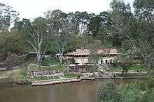 Fairfield Boathouse
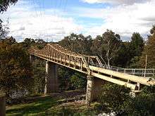 Fairfield Pipe Bridge in Yarra Park
 Fairfield Industrial Dog Object, Station Street, Fairfield
See also
- City of Northcote - the former local government area of which Fairfield was a part
References
- ↑ Australian Bureau of Statistics (27 June 2017). "Fairfield (State Suburb)". 2016 Census QuickStats. Retrieved 2017-07-03.

- ↑ Premier Postal History, Post Office List, retrieved 11 April 2008
- ↑ http://www.stationstreet.com.au/#
- ↑ http://profile.id.com.au/darebin/ancestry?WebID=120
- ↑ Golf Select, Yarra Bend, retrieved 11 May 2009
External links
| Wikimedia Commons has media related to Fairfield, Victoria. |