Fürstein
| Fürstein | |
|---|---|
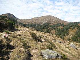 The Chli Fürstein (left) and the Fürstein (right) from the east side | |
| Highest point | |
| Elevation | 2,040 m (6,690 ft) |
| Prominence | 481 m (1,578 ft) [1] |
| Parent peak | Brienzer Rothorn |
| Coordinates | 46°53′44″N 8°4′11″E / 46.89556°N 8.06972°ECoordinates: 46°53′44″N 8°4′11″E / 46.89556°N 8.06972°E |
| Geography | |
 Fürstein Location in Switzerland | |
| Location | Lucerne/Obwalden, Switzerland |
| Parent range | Emmental Alps |
The Fürstein is a mountain of the Emmental Alps, located on the border between the cantons of Lucerne and Obwalden.
The closest locality is Flühli, on the western side.
References
External links

- Fürstein on Hikr
This article is issued from
Wikipedia.
The text is licensed under Creative Commons - Attribution - Sharealike.
Additional terms may apply for the media files.