Exclusive economic zone of North Korea
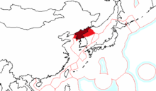
The exclusive economic zone of North Korea stretches 200 nautical miles from its basepoints in both the West Sea (Yellow Sea) and the East Sea (Sea of Japan).[1] The exclusive economic zone (EEZ) was declared in 1977 after North Korea had contested the validity of the Northern Limit Lines (NLL) set up after the Korean War as maritime borders. The EEZ has not been codified in law and North Korea has never specified its coordinates, making it difficult to determine its specific scope.
In the West Sea, the EEZ remains unspecified in the Korean Bay because China has not determined its own EEZ in the area. The border between the North Korean and South Korean EEZs in the West Sea cannot be determined because of potential overlap and disputes over certain islands.
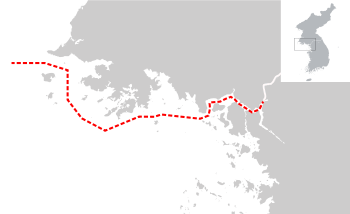
In the East Sea, the North Korean EEZ can be approximated to be trapezoidal-shaped. The border between North Korea and Russia's respective EEZs is the only such border that has been determined in East Asia. Here, the EEZ does not cause many problems, even with regards to South Korea, because the sea is not thought to be rich in resources.
History
The Korean Armistice Agreement specified a Military Demarcation Line as a land border between North and South Korea, but failed to determine a maritime border. The United Nations Command of the Military Armistice Commission (UNCMAC), however, unilaterally set two maritime borders, one at the West Sea (Yellow Sea) and one at the East Sea (Sea of Japan), known as Northern Limit Lines (NLL).[2] Ever since the legal status of the NLLs has been contested and clashes have taken place.[3] In 1973, North Korea explicitly challenged the validity of the West Sea NLL. UNCMAC had accused North Korea of intruding to the south of the NLL, to which North Korea responded by claiming that its maritime boundary lies south of the NLL.[4]
On 21 June 1977, North Korea declared an economic zone of 200 nautical miles. The zone become effective on 1 August. That day, North Korea also declared 50-nautical mile Military Boundary Zones in both the West and East Seas.[4] The North Korean exclusive economic zone (EEZ) had been born.[5]
South Korea objected to North Korea's EEZ plans, and has given a statement: "The [South] Korean government makes it clear that it is not recognizing North Korea's Military Boundary Zones and 200-nautical mile EEZs because they may bring about change in the status quo of the Korean Peninsula since armistice in 1953".[6] Japan protested the move as well, but China did not.[7]
Extent
North Korea has not passed a law on its EEZ. For this reason, it is not possible to define its outer limits. The country has, however, stated that the EEZ between neighboring countries or countries that are opposite one another "should be determined by consultation in accordance with the principle of an equidistant line or a median line".[8] North Korea has never specified the geographical coordinates of its EEZ claims.[9]
West Sea
The border between the North Korean and Chinese EEZs is not clear. It can be inferred from North Korean statements that the limit of its EEZ in the West Sea coincides with the limit of its Military Boundary Zone. Because the West Sea is fairly narrow, the combined 400-nautical mile EEZs of North Korea and China will overlap.[10]
The China–North Korea border on land has not been formally defined, but from treaties and statements it can be inferred to be the Yalu (Amnok) river.[11] North Korea disputes with China a number of small islands at the mouth of the Yalu. The ownership of these islands affects the possible course that the maritime border between the two countries, and thus the border of their respective EEZs, will take.[8] North Korea has specified its EEZ using the equidistant line method,[10] while China, in general, prefers the natural prolongation of land territory method. In the Korean Bay in the West Sea, however, China however also prefers the equidistant line method, because that would give it the maximum share of the waters.[7] Chinese academician Ji Guoxing has argued that the EEZs should take into account the specific conditions of the Korean Bay, such as China's longer coastline and historical fishing activities, and be based on the principles of equity and proportionality.[12] On the other hand, because China has not determined its EEZ in the West Sea, North Korea has probably adopted a similarly vague position so as to be flexible toward China.[13] Some kind of agreement about the maritime border reportedly exists between North Korea and China, but it is unclear if this pertains to the EEZ or the continental shelf boundary.[14] Which of the islands in the West Sea belong to North and which to South Korea will also affect the boundaries of the EEZs of the three countries there.[15]
Even if the issue with the islands were to be resolved, the North and South Korean EEZs would overlap, necessitating either one party to reduce its claim or the two to share some of the EEZ.[16] According to the United Nations Convention on the Law of the Sea, the EEZs in both the West and East Seas should be divided so as to leave no international waters between them, because the sea areas are less than 400 nautical miles in breadth.[17] The West Sea NLL would probably not legal as a permanent boundary of territorial waters because it violates the non-encroachment principle of the convention by cutting of North Korea from the open seas. This also has implications for the EEZ.[18] North Korea has signed the convention but not ratified it.[19]
East Sea
The EEZ in the East Sea is trapezoidal-shaped. The area is not a source of great confrontation between North and South Korea because South Korean vessels avoid it. It is also not thought to be rich in natural resources.[20]
The border between North Korea's EEZ with that of Russia is the only determined border of its EEZs, and indeed the only fully determined border of EEZs in all of East Asia.[5] It was determined in 1986. The problem with it is however that its terminus is not equidistant with South Korean or Japanese territory.[21]
North Korea is geographically disadvantaged when it comes to the determination of EEZs, especially in the East Sea where it is sandwiched between Russia and South Korea.[20] This fact might contribute to North Korea's reluctance to commit fully to the EEZ regime and negotiate EEZ boundaries with its neighbors.[22]
Economy
North Korea conducts fishing in its EEZ, mainly for the industrial sector. Some fishing for the artisanal sector takes place, too. Subsistence fishing has declined considerably over the years.[23]
A 2000 agreement between non-governmental fishing organizations of North and South Korea allowed South Koreans to fish inside the North Korean EEZ in the East Sea until 2005. About 400 South Korean fishing vessels conducted fishing in the area.[20]
Although China did not initially protest the establishment of the North Korean EEZ, it has subsequently accused it of hampering economic development on the mouth of the Yalu River, especially at Bohai Bay.[7]
See also
References
- ↑ Prescott & Schofield 2001, p. 25.
- ↑ Kim 2017, p. 17.
- ↑ Kim 2017, p. 18.
- 1 2 Kim 2017, p. 20.
- 1 2 Kim 2017, p. 51.
- ↑ Kim 2017, p. 21.
- 1 2 3 Kim 2017, p. 77.
- 1 2 Zou 2016, p. 157.
- ↑ Kim 2017, pp. 71–72.
- 1 2 Kim 2017, p. 22.
- ↑ Prescott & Schofield 2001, pp. 25–26.
- ↑ Lee & Lee 2016, p. 153.
- ↑ Buchholz 1987, p. 64.
- ↑ Johnston & Valencia 1991, p. 117.
- ↑ Prescott & Schofield 2001, pp. 25–28.
- ↑ Kotch & Abbey 2003, p. 179.
- ↑ Lee & Lee 2016, p. 191.
- ↑ Van Dyke 2009, p. 43.
- ↑ Lee & Lee 2016, p. 151.
- 1 2 3 Van Dyke 2009, p. 42.
- ↑ Prescott & Schofield 2001, p. 61.
- ↑ Johnston & Valencia 1991, p. 48.
- ↑ Pauly & Zeller 2016, p. 314.
Works cited
- Buchholz, Hanns Jürgen (1987). Law of the Sea Zones in the Pacific Ocean. Singapore: Institute of Southeast Asian Studies. ISBN 978-9971-988-73-9.
- Johnston, Douglas M.; Valencia, Mark J. (1991). Pacific Ocean Boundary Problems: Status and Solutions. Dordrecht: Martinus Nijhoff Publishers. ISBN 0-7923-0862-X.
- Suk Kyoon Kim (2017). Maritime Disputes in Northeast Asia: Regional Challenges and Cooperation. Leiden: BRILL. ISBN 978-90-04-34422-8.
- Kotch, John Barry; Abbey, Michael (2003). "Ending naval clashes on the Northern Limit Line and the quest for a West Sea peace regime" (PDF). Asian Perspectives. 27 (2): 175–204. Archived from the original (PDF) on 25 July 2011.
- Seokwoo Lee; Hee Eun Lee (2016). The Making of International Law in Korea: From Colony to Asian Power. Leiden: BRILL. ISBN 978-90-04-31575-4.
- Pauly, Daniel; Zeller, Dirk, eds. (2016). "Korea (North)". Global Atlas of Marine Fisheries: A Critical Appraisal of Catches and Ecosystem Impacts. Washington: Island Press. p. 314. ISBN 978-1-61091-626-4.
- Prescott, John Robert Victor; Schofield, Clive H. (2001). Furness, Shelagh, ed. "Undelimited Maritime Boundaries of the Asian Rim in the Pacific Ocean". Maritime Briefing. Durham: International Boundaries Research Unit, University of Durham. 3 (1). ISBN 978-1-897643-43-3.
- Van Dyke, Jon M. (2009). "Disputes Over Islands and Maritime Boundaries in East Asia". In Seoung Yong Hong, Jon M.; Van Dyke. Maritime Boundary Disputes, Settlement Processes, and the Law of the Sea. Leiden: BRILL. pp. 39–76. ISBN 90-04-17343-9.
- Keyuan Zou (2016). "China and Maritibe Boundary Delimitation: Past, Present and Future". In Amer, Ramses; Keyuan Zou. Conflict Management and Dispute Settlement in East Asia. New York: Oxon. pp. 149–170. ISBN 978-1-317-16216-2.