Ettrick Bay
| Ettrick Bay | |
|---|---|
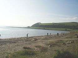 Ettrick Bay from the south showing it curving at the north with Kildavanan Point being visible. | |
 Ettrick Bay | |
| Location | Isle of Bute, Argyll and Bute Scotland |
| Coordinates | 55°50′39.592″N 5°8′33″W / 55.84433111°N 5.14250°WCoordinates: 55°50′39.592″N 5°8′33″W / 55.84433111°N 5.14250°W |
| River sources | St Colmac Burn |
| Ocean/sea sources | Atlantic Ocean |
| Catchment area | 22.5 kilometres (14.0 mi)2[1] |
| Basin countries | Scotland |
| Max. length | 1.7 km (1.1 mi) |
| Max. width | 0.960 km (0.597 mi) |
| Average depth | 20 metres (66 ft) |
Ettrick Bay is a wide, tidal, 218° facing, sandy coastal embayment located on the west coast of the Isle of Bute in the Firth of Clyde, within council area of Argyll and Bute in Scotland.[2] Ettrick bay was used for practice training for D-Day landings.[3]
Geography
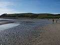
The bay faces the Kyles of Bute, that is a narrow sea channel that separates the northern end of the Isle of Bute from the Cowal peninsula, and offers excellent views of Isle of Arran.[1] The bay is bounded by a coarse sandy beach which is popular with tourists and local people. During low tide, the waters edge can be up to 500m from high tide mark.[1] A number of rivers flow into the bay including the Glenmore Burn, Ettrick Burn, Drumachloy Burn and St Colmac Burn.
At the north end of the bay, which mainly consists of rocky outcrops, lies the Kildavanan Point, with the feature known as Macallister's Gun, located close to the point. At the south end of the bay, lies the rocky outcrop called Island McNeil, which forms the outer boundary of the bay.
The surrounding area is mostly rural with agriculture being the main land use. Average rainfall for the region is 392mm compared to 331mm in Scotland as a whole.[1] Windy Hill is the largest peak on the Isle of Bute, which is located directly to the north of the bay and is 278m high. Other small hills surrounding the bay include Eanan Hill at 166m to the north east, Glenabea Hill behind Eanan Hill at 201m. Kilbride Hill at 256m which bounds Windy Hill at the east side, Muirton Hill at 256m which is at the south of Windy Hill. To the east and south of the bay, all the hills are shallow.
3.25 miles directly south of Ettrick bay lies the sheltered bay of St Ninians Bay that is named after the 8th century Christian saint Saint Ninian. The island of Inchmarnock can be seen from Ettrick bay and lies on a south by south west bearing of around 200° at a distance of 5 km from the bay, and is located at the northern end of the Sound of Bute in the Firth of Clyde on the same longitude as St Ninians Bay.
Settlements
The nearest town to the bay is Rothesay, Bute which is 4 km to the south west. The small coastal village of Port Bannatyne is located directly 3.25 km to the north east, on Ardbeg point of Kames Bay.
Features
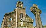
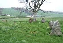
A Bronze Age stone circle is situated at St Colmac Farm, that is located south of the B875 road to Ettrick Bay from Port Bannatyne about 1 km northeast of the shore of Ettrick Bay. A Celtic cross, that is often associated with the stone circle, is located at the ruined 19th century church of St Colmac, about 100metres from the stone circle in a north west direction. A well known tourist attraction, and often associated together, they were built several thousand years apart.[3] At the bridge over Glenmore burn, lie concrete frames built for the British Army for exercises on Inchmarnock. The concrete frames represented practice Landing craft for D-Day landings.[3]
Gallery
 Ettrick Bay
 Ettrick Bay looking towards the island of Arran.
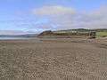 Looking towards the north and the point on the Kildavanan Point.
 Ettrick Bay. Looking south over a stormy Ettrick Bay. The island of Arran is visible in the distance.
- Plastic litter pickers, cleaning the beach of litter.
 This view of Ettrick Bay beach, taken from the cafe car park, shows an abandoned and wrecked fishing boat.
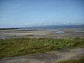 The beach from the car park looking south.
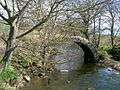 The ancient and ruined Drumachloy Bridge over the Drumachloy Burn.
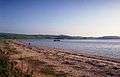 Ettrick Bay looking south.
 Fishing boat that was wrecked in 1994 and removed in 2007 when it became dangerous after a winter storm. The crew mistook low-lying ground for a channel to the north of the island and foundered.[4]
References
- 1 2 3 4 "Bathing water profile:Ettrick Bay" (PDF). SEPA. Retrieved 30 April 2017.
- ↑ "Ettrick Bay". Gazetteer for Scotland. School of GeoSciences, University of Edinburgh and The Royal Scottish Geographical Society. Retrieved 20 April 2017.
- 1 2 3 Hamish Haswell-Smith (2008). The Scottish Islands: The Bestselling Guide to Every Scottish Island. Canongate. p. 26. ISBN 978-1-84767-277-3.
- ↑ Elliott, Simpson. "Shipwreck at Ettrick Bay". Geograph® Britain and Ireland. Geograph Project Limited,. Retrieved 2 May 2017.