Etjo Sandstone
| Etjo Sandstone Stratigraphic range: Early Jurassic | |
|---|---|
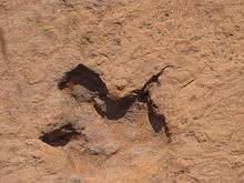 Dinosaur trace fossil in the Etjo Sandstone | |
| Type | Geological formation |
| Unit of | Etendeka Group |
| Overlies |
Omingonde Fm. (Waterberg Basin) Doros or Gai-As Formation (Huab Basin) |
| Thickness | 140 m (460 ft) |
| Lithology | |
| Primary | Sandstone |
| Location | |
| Location | Damaraland |
| Coordinates | 21°24′S 16°42′E / 21.4°S 16.7°ECoordinates: 21°24′S 16°42′E / 21.4°S 16.7°E |
| Approximate paleocoordinates | 30°12′S 8°48′W / 30.2°S 8.8°W |
| Region | Kunene & Erongo Regions |
| Country |
|
| Extent |
Waterberg Basin Huab Basin |
 Geologic map of Namibia with the Etjo Sandstone partly cropping out in the northwestern area (orange) | |
The Etjo Sandstone is an Early Jurassic geologic formation in northern Namibia. The formation overlies the Omingonde Formation in the Waterberg Basin and the Doros and Gai-As Formations in the Huab Basin and has a total thickness of 140 metres (460 ft).[1] Fossil theropod tracks of Prosauropoda indet., Theropoda indet., Tetrapodium elmenhorsti, Saurichnium anserinum, S. damarense, S. parallelum and S. tetractis have been reported from the formation, deposited in an aeolian environment.[2][3]
See also
References
- ↑ D'Orazi et al., 2015, p.73
- ↑ Weishampel, et al. (2004). "Dinosaur distribution." Pp. 517-607.
- ↑ Otjihaene-Maparero farm at Fossilworks.org
Bibliography
- D'Orazi Porchetti, S.; H.B. Mocke; M. Latiano, and A. Wagensommer. 2015. First record of Otozoum from Namibia. Lethaia 48. 72–82. Accessed 2018-08-28.
Bubliography
- Weishampel, David B.; Dodson, Peter; and Osmólska, Halszka (eds.): The Dinosauria, 2nd, Berkeley: University of California Press. 861 pp. ISBN 0-520-24209-2.
This article is issued from
Wikipedia.
The text is licensed under Creative Commons - Attribution - Sharealike.
Additional terms may apply for the media files.